The Wonderful Wetland Ecology Bus Tour
On the 12th October I was fortunate enough to have a seat on the two-day Wonderful Wetland Ecology Bus Tour, a training course on the ecological drivers of wetlands (geomorphology, hydrology and water quality). On this tour of wetlands across the Loddon floodplains (North Central Victoria), we were introduced to a suite of different vegetation types and got to experience first hand their response to the wet spring of 2016 and wet autumn of 2017. Damien Cook, who is the Principal Ecologist at Rakali Ecological Consulting Group, shared his extensive knowledge of the region, its wetlands and their flora and fauna. As an added bonus we were also joined by Dixie Patton, a Barapa Barapa Traditional Owner, who shared his stories and provided a very practical account of Aboriginal history around these wetlands.
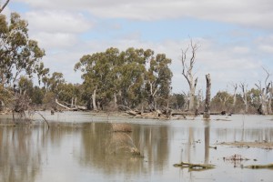
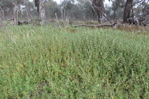
Intermittent swampy woodland/lakebed herbland complex at Yando Swamp. Note the dead trees which resulted from almost permanent inundation.
Our first stop was Yando Swamp, a deflation basin on the Loddon River floodplain. Stepping through the vegetation communities we were able to recognise the role between floodplain elevation and flooding frequency, from the shallow and less frequently inundated Lignum swampy woodland to the intermittent swampy woodland/lakebed herbland complex which was still partially inundated as a result of the preceding wet spring and autumn. Locally known as Lake Yando, this wetland was kept artificially full by irrigation outfall resulting in the death of trees in the deeper sections. The hydrological regime is now managed to incorporate late season drying, more reflective of the sites natural hydrology, and is resulting in recruitment and establishment of River Red Gum seedlings. Long-time local Paul Haw (and author of “Footprints across the Loddon Plains”) provided us with an insightful account of the pre and post-European history of the area and showed us an Aboriginal cooking mound on the swamp fringes. Formed through hundreds of years of cooking, and constructed using stone brought in from much further afield, the remnants of these ovens are still clearly visible to the trained eye, despite their gradual destruction during the years since European arrival.
We then visited Leaghur State Park, home to the largest natural black box forest in Victoria. Stepping off the bus we were immediately greeted with an extensive cover of common Nardoo (Marsilea drummondii), a clear signature response to the inundation event of 2016/17. Nardoo was an important food source for Aboriginal people and the area contains numerous reminders of the significance this site holds for the Barapa Barapa people. The vegetation across the floodplain tied in with subtle elevation differences, with Gilgai depressions still showing inundation responsive vegetation signatures (e.g. wetland sedges and herbs) and the longer-term inundation history of the floodplain being evidenced by the extensive black box forest.
Common Nardoo on the Leaghur State Park floodplain.
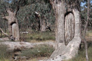
Scar trees signifying site use by the Barapa Barapa people.
Our final stop on day one was Griffiths Lagoon. This is another deflation basin but differs to Yando Swamp in that it has a series of deeper interconnected channels on the wetland bed. The origin of these remains a mystery but their presence has resulted in some defining bands of lake bed herbland. My first impression was that the wetland fringes were largely weed dominated but on close inspection, the extensive vegetation cover was largely composed of native herbs. The hydrology of this site is still considered largely intact, thus explaining the retention of this native vegetation assemblage.
Drying lake bed herbland at Griffiths Lagoon
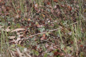
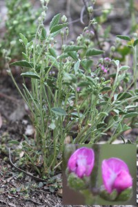
Sweet fenugreek (Trigonella suavissima)
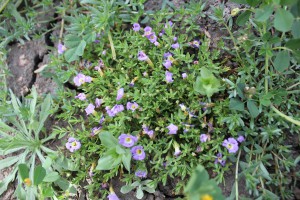
Small monkey flower (Mimulus protrastus)
The endangered hoary scurf-pea (Cullen cinereum)
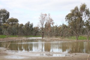
On day two ventured out to Wirra-lo wetlands near Cohuna where Ken and Jill Hooper have been working tirelessly to reinstate wetlands across their former irrigated dairy farm. This is underpinned by a collaboration with the North Central Catchment Management Authority (CMA), the Department of Environment, Land, Water and Planning and the Victorian Environmental Water Holder and has resulted in a new precedent for using environmental water for habitat re-instatement .You can find a great account of the project here but suffice to say, the early outcomes are impressive. For me it was a real eye-opener as to the potential for re-vegetating wetlands in order to speed up recovery and to fast-track habitat reinstatement. The vegetation response has been kick started using direct-seeding and planting of a host of aquatic and fringing species. Almost every plant we saw growing in the wetland was a result of these works. Most of our restoration projects work on a set-and-forget philosophy where we add the water and let the plants do the rest. So for those sites where things might not be responding as quickly as anticipated, or where there are some key species missing, Damien’s examples have given me much food for thought.
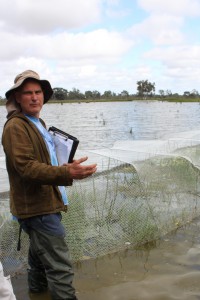
Damien Cook discussing the use of netting to protect vegetation from waterbirds.
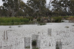
Guards providing protection for establishing wetland plants.
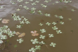
Reintroduced narrow leaf and commonNardoo.
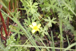
The rare swamp buttercup – another reintroduced species at Wirra-lo.
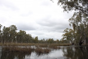
Deeper sections and corresponding vegetation of Reedy Lagoon.
Our final stop was at Reedy Lagoon, a former channel of Gunbower Creek which was also once the course of the Goulburn River. This billabong formed when the Gumbower Creek changed its course during a flood event a few hundred years ago. Unlike the other sites, this site is dependent on more frequent inundation. It now receives environmental water on a regular basis to mimic flooding frequencies which would have occurred prior to the construction of large storages in the upstream section of the Murray River. A combination of fringing riverine swamp forest, tall marsh, aquatic herbland and floodway pond herbland all rely on frequent flooding events and thus provide a contrasting example to the infrequently flooded environments of the other sites. And given the reliability of water in this part of the landscape, the area is rich with Aboriginal culture and worthy of investigation by anyone with a interest in this significant chapter of Australia’s history.
There really is no better way to gain an appreciation of the dynamics and requirements of our aquatic ecosystems than getting out there and looking at the vegetation and piecing together our understanding of site history – be it through technical investigations of flood frequency, understanding landuse change and looking for and knowing the signatures of Aboriginal history. They all combine to tell a story and help inform our management of these systems into the future. And having local experts to impart their knowledge make the jigsaw all the more easier to assemble. So if you have an interest in the conservation of aquatic ecosystems, I would well recommend getting on board a bus trip like this. You can find more information about upcoming events and training opportunities on the Rakali website.