What exactly did Matthew Flinders see in Port Phillip Bay in 1802?
One of the interesting things about digging through the history of the Avalon area for the project at Big Marsh in The Spit Nature Conservation Reserve (see this blog for more information), was the discovery that Port Phillip Bay is one of the few places where Matthew Flinders actually came ashore during his voyage along the southern Australian coastline almost 220 years ago.
In 1802, Matthew Flinders first landed on the opposite side of Port Phillip Bay (where he climbed Arthur’s Seat – the peak named 10 weeks prior by John Murray on the Lady Nelson) to record observations of his surroundings, before later setting off with provisions to last three days in a smaller vessel with crew to explore the rest of Port Phillip Bay.

On the 30th of April 1802 he was approaching the western shore of Port Phillip Bay, where he said:
“At noon, I landed to take an observation of the sun… my position being nearly at the northern extremity of Indented Head. Some bearings were taken from the brow of a hill a little way back; and after a dinner of which the natives partook, we left them on friendly terms, to proceed westward in our examination. The water became very shallow abreast of a sandy point, whence the shore trends nearly south-west; and there being no appearance of an opening to the sea this way, I steered across the western arm, as well to ascertain its depth as with the intention of ascending the hills lying behind the northern shore. Two of the peaks upon these hills had been set from the ship’s deck at sunset of the 25th, at the distance of thirty-seven miles; and as their elevation must consequently be a thousand feet, or more, I expected to obtain from thence such a view of the upper parts of the port, as would render the coasting round it unnecessary. The width of the western arm was found to be six miles; and the soundings across augmented regularly to 6 fathoms in mid-channel, and then decreased in the same way; but there was less than 3 fathoms at two miles from the northern shore. That side is indeed very low and marshy, with mud banks lying along it; and we had difficulty in finding a dry place to pitch the tent, and still more to procure wood wherewith to cook the ducks I had shot upon the banks.” (Flinders 1814)
While this appears to be a little further around the coast to the west (within Corio Bay) from what is now known as The Spit, it is clearly nearby. From his description, we can ascertain that this area was not generally covered with woody vegetation suitable for burning – which indicates a lack of trees and larger shrubs. This was confirmed the next day, on the 1st of May 1802, when the party set off towards what is now called the You Yangs:
“At day dawn I set off with three of the boat’s crew, for the highest part of the back hills called Station Peak. Our way was over a low plain, where the water appeared frequently to lodge; it was covered with small-bladed grass, but almost destitute of wood, and the soil was clayey and shallow.” (Flinders 1814)
This description is also consistent with the annotations made on a more detailed map drawn by Acting Surveyor General of NSW, Charles Grimes, who was sent to assess Port Phillip a year later. He noted this area of land was “Swampy in general near the shore, grassy plains back to the foot of the Mountains. The soil very bad and stony. No Timber.”
Returning to Matthew Flinders’ account, as he approached the You Yangs on the 1st May 1802, he said:
“One or two miles before arriving at the feet of the hills, we entered a wood where an emu and a kanguroo were seen at a distance; and the top of the peak was reached at ten o’clock… Towards the interior there was a mountain… eleven leagues distant; and so far the country was low, grassy, and very slightly covered with wood, presenting great facility to a traveller desirous of penetrating inland. I left the ship’s name on a scroll of paper, deposited in a small pile of stones upon the top of the peak; and at three in the afternoon reached the tent, much fatigued, having walked more than twenty miles without finding a drop of water.” (Flinders 1814)
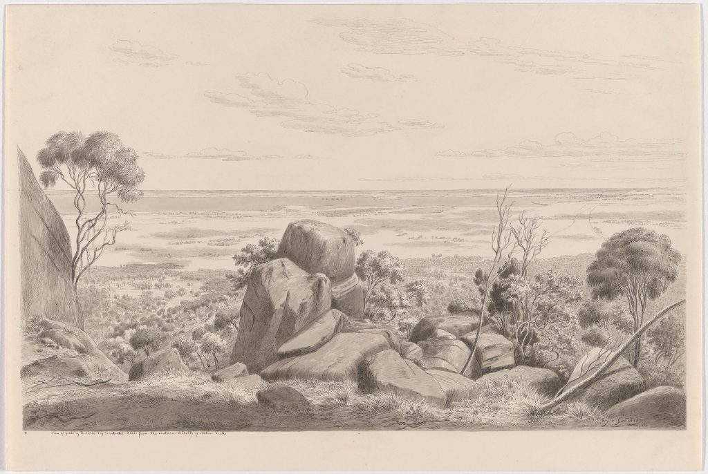
Reaching that peak also provided Flinders with a great vista that people continued to visit over the years (and still do today). Fortunately, one of those relatively early visitors was landscape artist Eugene von Guérard in 1858, who made the sketch below, looking back to the south over the same ground that Flinders had walked 56 years earlier.
Did you, like me notice something small but important in Flinders’ account?
The fact that he dined peacefully with people from the local Wadawurrung tribe, before setting off is both fascinating and a tantalising snippet of information about early contact between cultures. These three Aboriginal people had interacted with Flinders throughout that day, before he set off for Station Peak (to read more of Flinders Account of Port Phillip Bay, see below).
This encounter also took place before the fateful story of convict William Buckley began in the same general area (the following year in 1803) – all barely three decades before dispossession and disruption of life for the Wadawurrung Traditional Owners would occur in an especially comprehensive and rapid fashion from the 1830s. Had it not been for the alternative settlement in Hobart taking priority, this might have happened even sooner.
This early account is also a reminder of how this landscape, as Flinders saw it, had been actively managed and shaped by the Wadawurrung people, often in such a way that favoured grassy vegetation communities and an open structure on the plains. Ironically this is the very character that made the land especially attractive for Europeans to arrive with their grazing livestock. For an excellent, very detailed analysis that demonstrates vegetation changes over time and the influence of Aboriginal land management practices to the south at the nearby Bellarine Peninsula, please refer to Lunt (1998).
References (click on links to download pdf files):
Flinders, M. (1814). A Voyage to Terra Australis. Volume I. G. & W. Nicol, London (see relevant excerpt below)
Lunt, I. D. (1998). Two Hundred Years of Land Use and Vegetation Change in a Remnant Coastal Woodland in Southern Australia. Australian Journal of Botany 46: 629-647.
Pages from 1802 - Flinders - A_Voyage_to_Terra_Australis - Port Phillip Bay