“We can’t engineer away flooding” – La Niña event highlights the importance of retaining and restoring wetlands in both urban and rural Australia
The recent stories of flooding across the eastern part of our continent have once again brought the complex issue of floodplain development into sharp focus.
Let’s start by thinking a little about land use change in rural Australia…
Across the rural landscape, where infrastructure development is more sparse, and the memory of farming families often dates back generations, a level of caution, respect for, and understanding of the inevitability of these occasional events has permeated the psyche of the older generation in a way that influences the way they see, understand, live and behave in the landscape. It influences their land management decisions and their appreciation of and appetite for risk.
However, in parts of the rural landscape where land ownership changed during the long Millennium Drought years, and where that generational knowledge was lost, a parallel process of land-use intensification has allowed an entirely different set of expectations to develop.
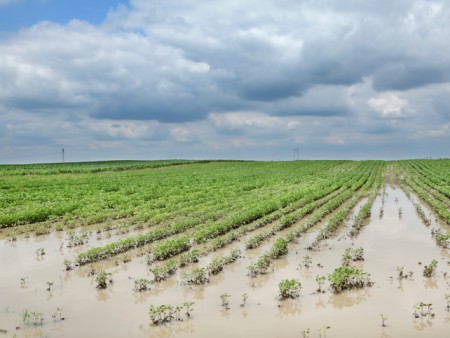
Vast areas of south-eastern Australia once considered too wet have been converted to cropping or plantation forestry over the past 20 years by a new generation who may not have witnessed or been told of the wetter epoch that influenced the land management decisions of their forebears. And so now, at the first sight of inundation, new drainage works are sometimes undertaken to try to address this risk and allow for the change in land use to be maintained. Areas of large-scale commercial plantation establishment have also actively influenced the future ability of some areas to inundate or produce runoff, by impacting upon groundwater recharge and the standing level of the water table.
At a place like Bool Lagoon, a Ramsar site in the south-east of South Australia, land use change has influenced upstream inflows (via forestry and extraction for irrigation) and also led to new pressure being applied seeking to alter decades old operating rules for water levels in this wetland of international significance (due to cropping of surrounding land). Yet those existing operating rules saw Bool Lagoon hold water permanently through the late 1980s and and early 1990s, the last wetter climatic epoch we experienced in south-eastern Australia.
This is just one example of many I have seen or learned about across the south-eastern states (NSW, Vic, SA and Tas) through our work at NGT, and where future climatic trends will challenge our perception of the capabilities of the landscape and how we manage water within it.
Individually of course, each of these actions may seem logical and have a sound economic basis.
But when either episodic heavy rainfall events hit (more of these are predicted under future climate change scenarios) or if a wetter climatic epoch returns, the collective impact of those individual actions means that all that extra water has to go somewhere. Where artificial drainage of the landscape has been enhanced, more water will be heading downstream, more quickly.
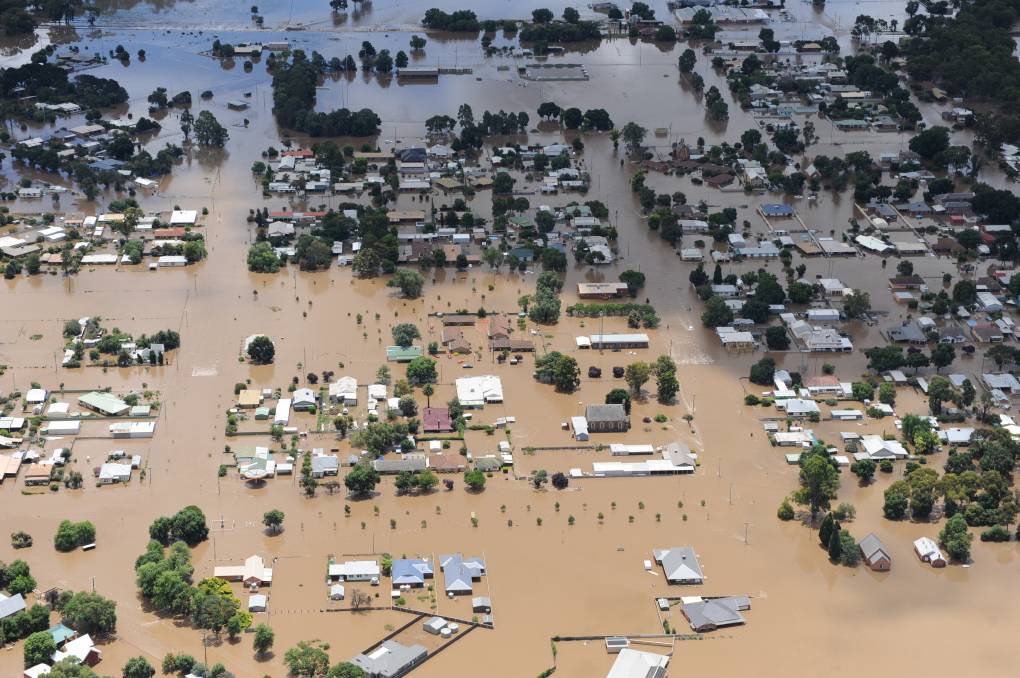
That can only mean one thing – a higher risk of flooding in other parts of the landscape: be that other rural farmland or, even further downstream, in the places where most people live. Remember that in Australia many towns and cities are built on the floodplains adjacent to creeks, rivers and estuaries.
But what about land development in urban Australia?
The issue of land-use change in urban Australia – particularly around our large cities – is even more acute, where the collective memory of past flooding was often lost entirely when land was sold and ‘banked’, sometimes decades ago, by major corporate investors speculatively preparing for inevitable future waves of urban development. Indeed the flatter the land, the higher the perceived value based on a lower predicted cost of site preparation and ultimately the number and style of lots that the development might yield.
Yet of note, it is this flatter land, when situated in valleys or in coastal areas at the terminus of larger waterways, that is integral to how nature manages flooding. After all, they are called “floodplains” for a reason.
Urban development of wetlands and floodplains continues apace in Australia, especially around our major cities, and brings with it two acute challenges in particular that intensify the risk of flooding where it is not wanted:
- the laying down of vast areas of hard surfaces (roofs, roads, pavement, driveways) which produce rapid, flashy runoff that exacerbate flooding risk, while minimising permeable surfaces (backyards, parks, open space, wetlands) that are capable of attenuating flow, infiltrating the soil, recharging groundwater and improving water quality.
- the physical infilling of in-stream or off-stream wetland features, which reduces the volumetric storage capacity of the original natural waterway and/or its floodplain. A waterway that can’t readily re-engage its floodplain will either cause an increased risk of flooding downstream, or will eventually force its way back onto its former floodplains when levels get high enough – developed or not. Sometimes, as in the case of the extreme examples we have seen recently, it can do both at the same time.
A relevant example is a case study site north of Melbourne, Hanna Swamp, where we have spoken about these issues at length in previous newsletters (see here for the story of Hanna Swamp). Development plans are not yet finalised for this area, but the tensions and conflicts are apparent, namely between:
(A) – the provision of affordable housing (government policy),
(B) – development profitability (a key objective of land developers), and
(C) – the requirements of the Healthy Waterways Strategy and the Planning Scheme as they relate to waterway, wetland and floodplain management (also government policy).
Historically, A and B have trumped C, but there is a growing awareness that this approach is not meeting the needs of the future residents of these developments, nor their future local environment. Put simply, we need to do much better.
As we have seen with flooding events across Australia over recent times, many urban development within floodplains will go under water at some point – it is inevitable. Tony Weber, who was interviewed by Fran Kelly on the ABC Radio National Breakfast Program last Wednesday (24th March) put it rather succinctly when he said that in Australia “we can’t engineer away flooding“. You can also listen to that very insightful interview below.
Summary
While no amount of engineering can reduce the risk of unwanted inundation to zero (as also explained by this other ABC news article), there are some sensible things we can do to improve our ability to manage these events.
First and foremost, retaining and restoring wetlands across both rural and urban Australia, and integrating them as genuinely valued features into the way we manage land, is an incredibly sensible place to start.
If you would like NGT’s advice or practical support with restoring a wetland on your property, then please contact us by email.