Cunningham Swamp: Another potential wetland restoration story in Melbourne’s urban growth zone
Over the past couple of years we have started to discuss the stories of Hanna Swamp, Herne Swamp and the Wallan Wallan Wetlands as initial case study sites for exploring the complex web of policy and practical challenges that face wetlands in Melbourne’s urban growth zone.
However, these wetlands are just the tip of the iceberg – and this subject continues to pose serious challenges for many areas earmarked for urbanisation around Melbourne, as this type of land transitions out of its previous (usually agricultural) use. Indeed it is that history of agricultural use that is proving to be a significant confounding factor, as artificial drains, diversions and dams – along with modified or degraded present site condition – are often impacting on the way the planning and development ‘system’ (with its many and varied moving parts) interprets and treats such land, as well as how its values and capabilities are viewed.
The net effect is that natural features are often partly or fully overlooked – things like the original waterways, wetlands and floodplains, which although modified, still clearly exist. This is because the development and planning system, in its current form, effectively incentivises the maximisation of developable area as the highest order priority for most of the participants in this system. As a result, the original state or future restoration potential of environmental features in urban growth areas – especially large natural wetland or floodplain features, which by their very nature often take up a lot of space – are usually not taken into account nor prioritised.
It is interesting to note that the Victorian Government itself continues to produce an increasing number of strategies and policy documents for urban growth areas (which cover water management, waterways, liveability and Traditional Owner aspirations) that recognise and seek to overcome these constraints. However, the system as it currently stands – despite its many improvements on planning outcomes of the past – still has a significant ‘blind spot’ when it comes to wetland features and waterways whose physical form may have changed or may not meet arbitrary ‘remnant vegetation’ quality thresholds in their current, modified state.
For anyone who has been following NGT’s work for a while, you will recognise that the current situation runs the risk of major restoration opportunities being missed – and with them, the associated liveability and wide range of other benefits to future communities. We know from experience just how dynamic and responsive wetlands in particular are to even seasonal changes in hydrology, let alone restoration, which can set a site on a new trajectory in rapid time. On behalf of the future communities who will call these areas home, we need to try to do better.
With this background in mind, today we are introducing you to another important natural wetland feature in Melbourne’s urban growth zone – this time to the south-west of the city – at Point Cook. Cunningham Swamp was brought to our attention by the community some time ago, along with a number of other wetlands around Melbourne’s urban fringe, and we were fortunate to be able to take a closer look at the site over the past 12 months, thanks to the support of a Communities Environment Program grant from the Australian Government. We hope that the report we have produced will help inform the various parties with an interest in the site about the trajectory of change experienced by the wetland over the past 70 years, and clearly articulate its restoration potential. We also hope this will benefit the planning processes described above.
Restoration potential of Cunningham Swamp
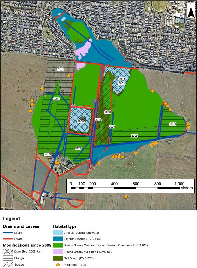
The condition of residual wetland vegetation at Cunningham Swamp has been compromised by a combination of factors, including modification of inflows, site drainage, groundwater changes, and agricultural activities such as grazing, ploughing, and track building across much of the wetland basin. However, despite this history of modification, the wetland ecosystem has shown resilience through the persistence and recovery of high value habitats.
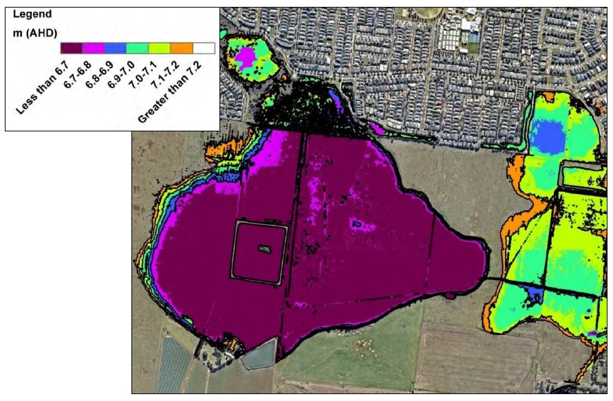
High resolution aerial imagery is available from 2009, and combined with recent imagery (to 2021), captures a transition of areas that were essentially bare earth after nearly 10 years of drought in 2009, to now support native wetland vegetation that has naturally regenerated. This is supported by the fact that current partial recovery has occurred after the drought, despite the current drains and other modifications exerting a drying influence, which indicates the further trajectory of recovery that is highly likely under a future restoration scenario if the natural wetland feature is retained, hydrologically restored and adequately protected for that purpose.
Additionally, most (but not all) modifications that exert a hydrological influence on the wetland are reversible and – in most cases – the works to achieve this are relatively straightforward to implement.
When considering the ever-diminishing opportunities for wetland restoration around Melbourne, the Cunningham Swamp wetland complex offers a compelling case: despite modification, this large natural wetland area still retains an impressive suite of eco-hydrological values and has excellent full restoration potential.
The unique characteristics of the wetland complex offer the possibility to enhance and recreate wetland habitat on a regionally significant scale, with positive outcomes for threatened vegetation communities, flora and fauna. It will also provide complementary habitat that will likely enhance (and in turn also benefit from its proximity to) the nearby Port Phillip Bay (Western Shoreline) & Bellarine Peninsula Ramsar Site.
Finally, Cunningham Swamp presents an opportunity to establish an open, natural public space which provides community, cultural and environmental benefits – as a vital catchment management asset that is accessible to (and improves liveability for) the surrounding current and future urban population. In this way it would further contribute to a network of important areas of open public space for all metropolitan residents.
To read the full report, you can either download it here, or use the viewer below.
This project was funded by a grant from the Australian Government, Communities Environment Program.