Hanna Swamp: a forgotten Wallan Wallan wetland that highlights the challenges of ‘business as usual’ urban development

Next month NGT will be publicly sharing another Discussion Paper on the Wallan Wallan wetlands, to follow on from one we released in March last year (2019), where we explored the risks and opportunities associated with Herne Swamp. This floodplain wetland at the headwaters of Merri Creek is within Melbourne’s northern growth corridor and, despite modification, still temporarily inundates on a semi-regular basis.
To give you a taste of the second discussion paper, which will explore in more detail how urban development is currently proposed to interact with modified natural waterways and wetlands around Wallan, today we’re going to run through a few maps that illustrate the history of a wetland called Hanna Swamp. This wetland is named after its late 1800s owner and parliamentarian Patrick Hanna (1819-1890).
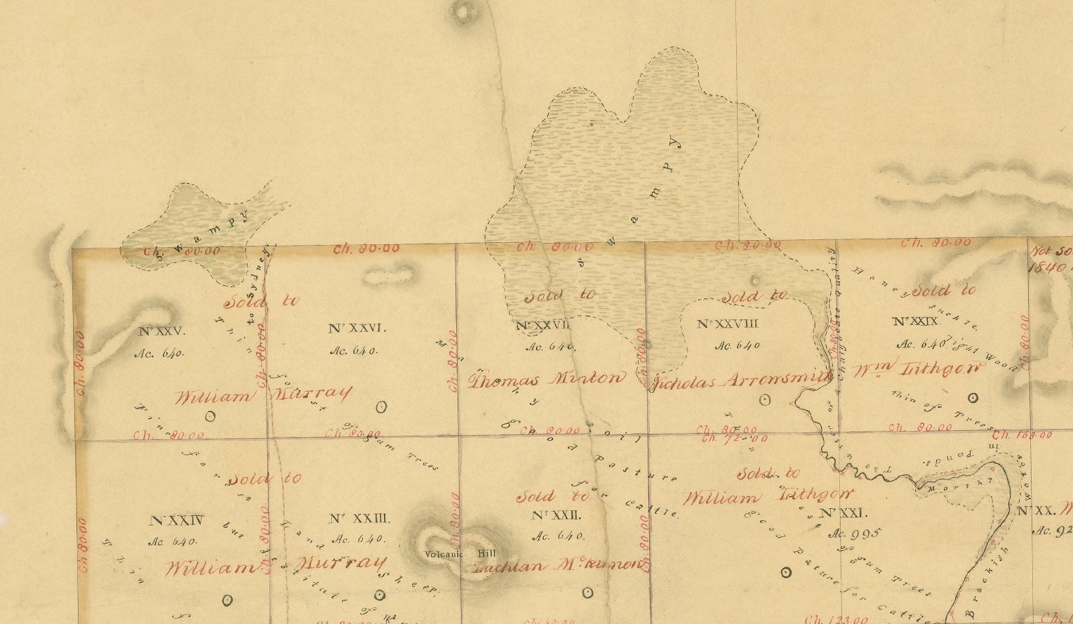
Firstly, to get your bearings, here is a map from 1840 showing the position of Hanna Swamp relative to Herne Swamp. On this map you can see the original overland route from Melbourne to Sydney skirting the eastern side of Hanna Swamp. This area is located approximately 50 km north of Melbourne.
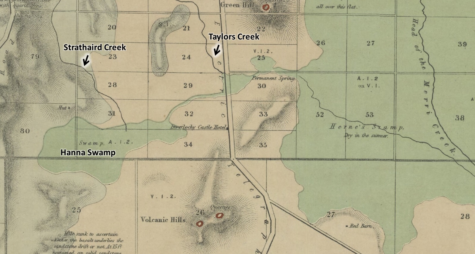
For a bit more detail, let’s have a look at another map from 1862. This clearly shows Hanna Swamp as a natural in-stream wetland of Strathaird Creek, which joins with Taylors Creek and then flows into the eastern side of Herne Swamp, at the headwaters of Merri Creek.
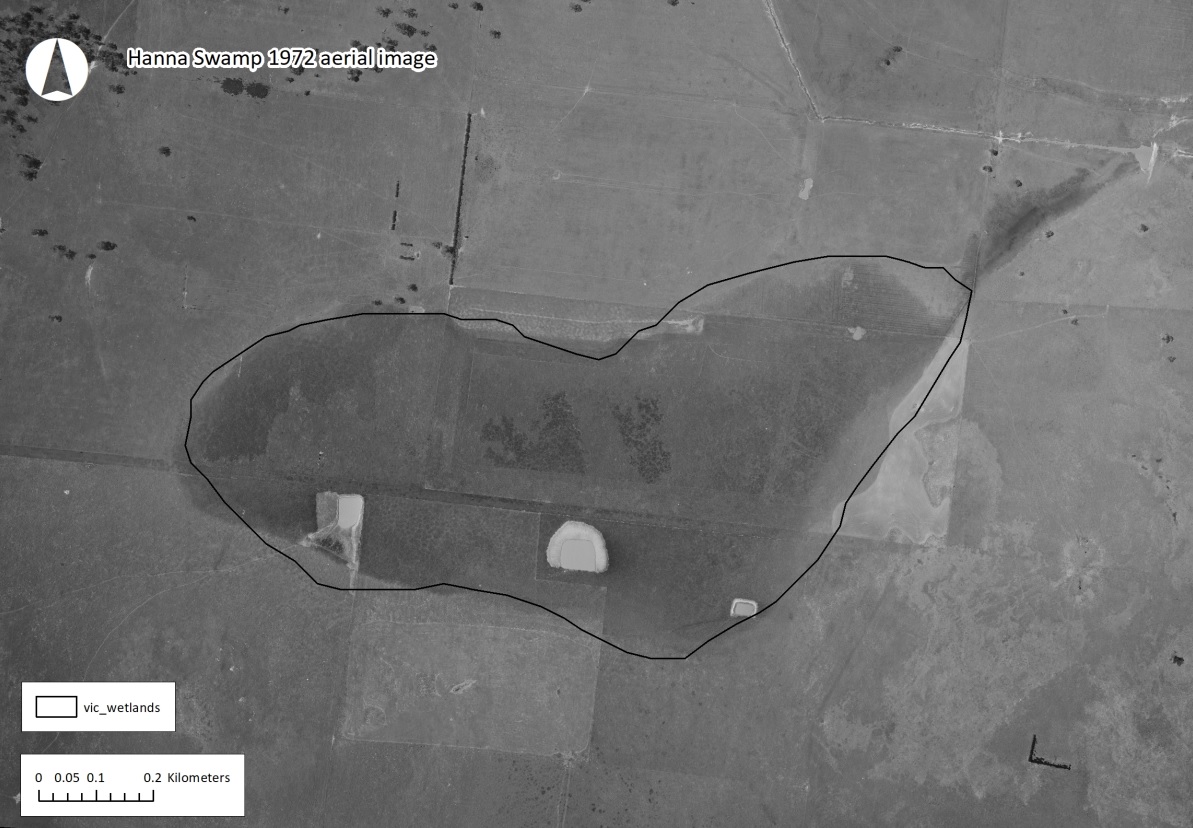
Fast forward just over 100 years and Hanna Swamp is still visible in the landscape in 1972, albeit by this time some upstream changes have occurred to Strathaird Creek (with a diversion drain in place), modifying the natural flow path and reducing water availability to Hanna Swamp. Dams have also been dug into the bed of the southern part of the wetland. However, despite these changes, thanks to local runoff and groundwater, the wetland appears to be persisting across the bulk of its original footprint at this time.
As has occurred with so many wetlands in Victoria, Hanna Swamp was eventually comprehensively drained for agriculture, and only fragments of its original perennial native vegetation persisted. The following image (a digital terrain model) shows the estimated original ‘cease to flow’ sill level for the main wetland feature (based on the level of the natural narrow outflow point) – with everything above that level coloured brown. It also clearly highlights the network of shallow drains that caused the major final alteration to the hydrology of the wetland. This herringbone pattern of artificial drainage is commonly seen across the bed of extremely flat wetland sites that have been drained and is a means to overcoming the lack of gradient to remove surface and/or groundwater.

As regular readers of our monthly newsletter will know, for a site like this in the agricultural landscape, a drained wetland is never really lost – just think of it as being in an artificially induced state of drought. Return the water by reversing drainage impacts, as Nature Glenelg Trust have now done at dozens of wetlands across Victoria, and both ecological values and hydrological function can be recovered and restored in very quick time.
This means, artificial or not, once the drought breaks, natural wetlands are very forgiving ecosystems, capable of supporting wetland plants that are especially adept at bouncing back (e.g. from seed, rhizomes or other propagules), as well as a wide range of animals recolonising all by themselves, once the water returns.
[Side note: It is interesting to note that unlike like many terrestrial (i.e. dry-land) ecosystems, which are more stable in their appearance and composition, many wetland types support a wide range – sometimes a majority – of values (plants and animals) that are seasonal or ephemeral. In lay terms, this means that even at completely intact sites, dormancy phases, or for some animals migration, can mean those values quite literally disappear from view for months or even years at a time. This in turn is the magic biological ingredient that underpins the return of these values once we restore degraded sites, by using the natural adaptations of wetland species to our to advantage.]

So while Hanna Swamp currently appears lost, sustained recovery is potentially only a single season away. Restoration works themselves are also much more cost and time effective than the effort required to create something approaching equivalent value in an urban constructed wetland, and restoration causes a lot less disturbance because you are literally working with a natural landscape feature that already exists.
Like nearby Herne Swamp, Hanna Swamp is currently earmarked for development within Melbourne’s northern growth corridor, and it faces an uncertain future.
Despite being a natural wetland feature on the original alignment of Strathaird Creek, there is a chance that suburban development will not recognise the location of the original waterways of the Upper Merri Creek catchment and may instead simply entrench the changes that were made to facilitate past agricultural development, permanently locking in the detrimental impacts of those changes to waterway health. This is also despite the fact that this is a flood-prone landscape, where building on drained in-stream floodplain wetlands carries significant risks (both on-site and downstream).
Even though the actual development works may be several years away, as we speak, early pivotal layout decisions are being made for this area in the Precinct Structure Plans (PSPs) being developed by the Victorian Planning Authority. Yet there does not appear to have been any detailed comparative analysis made between the legitimate choices available for how these catchments are ultimately developed, such as whether flooding and other waterway risks could be better managed in alternative ways to ‘business as usual’. For example, whether the original waterways, including in-stream features like Hanna Swamp and Herne Swamp, could be integrated into development designs and turned into community assets with multiple benefits, is an alternative option that has not yet been assessed or considered.
Fortunately, there is a growing awareness that this is a significant current gap in the policy framework and planning processes that typically apply within Melbourne’s urban growth zone. Hence now finding a way to seamlessly and logically deal with this complex issue, when there are so many players, PSPs at different stages of development and a wide range competing interests, is the real challenge.
We’ll explore this topic further in more detail next month, but for now we’re continuing to talk to the various people and organisations with an interest in this important issue, to get a sense of what may be possible for the Wallan Wallan wetlands.