Part 6: The Lake Momboeng Naming Story takes an unexpected turn!
In the most recent update to this story (Part 5), we explored some recently uncovered 1970s correspondence in the archives between the Victorian Place Names Committee (PNC) and regionally-based local and state government bodies, that shed some light on how the lake became officially registered by the PNC (and indeed is still signposted on the road) as “Lake Mombeong”.
Although I had scoured all the early pastoral maps, Government Gazettes and government notices in the early newspapers, the PNC correspondence referred to one piece of key evidence that I was yet to lay my hands on: the original Pastoral Run file held by the Department of Crown Lands and Survey in Melbourne. Around the same time, I was also emailed (by Michael Godfrey, who has done extensive research on the middens of Long Swamp) a puzzling image of the name on the cover of that very same file, which he had seen in the Public Records Office of Victoria (State Archives) in Melbourne, where the file was now located.
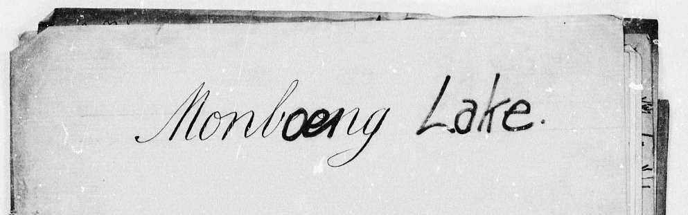
The puzzling image of Lang’s Pastoral Run file cover entitled: Monboeng Lake
The reason I was puzzled by this is because you can see on closer inspection that originally this had been written as either “Monbeong or Monbrong”, only to be later overwritten to say “Monboeng Lake”. (Note: Monbeong was the name entered in the government register for the coastal portion of the run that was formally established in the early 1850s, retrospectively found to occur within the arbitrarily defined “settled district”).
Needless to say, I decided it was time to finally seek out this key piece of the puzzle that would hopefully reveal the so far lacking primary source evidence that we need to bring this story to a more satisfactory conclusion. I was also hoping the file may help verify the precise date that the Lang Brothers established a run by this name, to inform our understanding of early changes to the hydrology of Long Swamp.
While unfortunately this latter question wasn’t ultimately answered by the contents of the file, it has given our naming story another interesting twist… (If you look closely at the spelling of a key word in the title of this blog, you’ll see where this is heading!)
The file contained the very earliest papers relating to the establishment of the run, after the Port Phillip District of NSW (present-day Victoria) became subject to the Orders in Council of 9th March 1847, under the Australian Lands Act 1846. Those orders sought to bring uniformity to the way that pastoral runs were administered across the various Districts within the colony of NSW, and required all lessees to lodge standardised paperwork to formalise their Station runs (i.e. pastoral holdings) under the new laws. All this means that even though the Discovery Bay coastal run was established in c. 1845 (by Dr. James Dickson, who held the first license for coastal land near the Glenelg River mouth), the first consolidated file and paperwork for the run (as with all runs in Victoria) appears to only commence in late 1847 or early 1848. Earlier references do exist but are a greater challenge to locate – a story for another day!
However, fortunately for us, the Lang Brothers who took over the run in 1846, named it after getting to know the local Indigenous people (see Part 4), and were still the holders of the pastoral licence at the time the paperwork was lodged in January 1848.
That standard paperwork was a two page form with an application (page 1) and a schedule (page 2) describing the run, as shown:
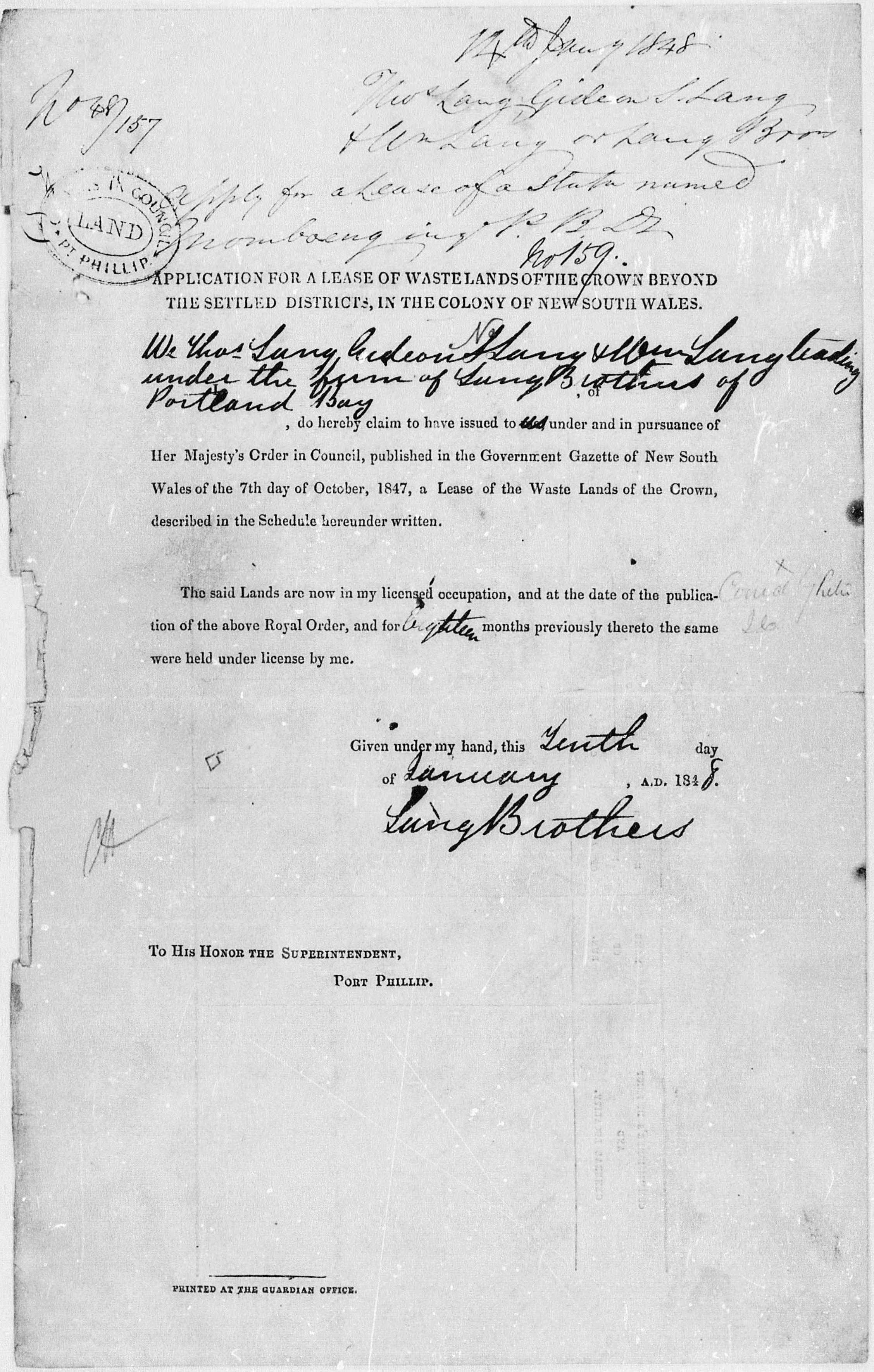
Page 1 of the form – “Application for a Lease of Wastelands of the Crown Beyond the Settled Districts, in the colony of New South Wales” – filled out by the Lang Brothers and later processed and allocated Licence Number 159.
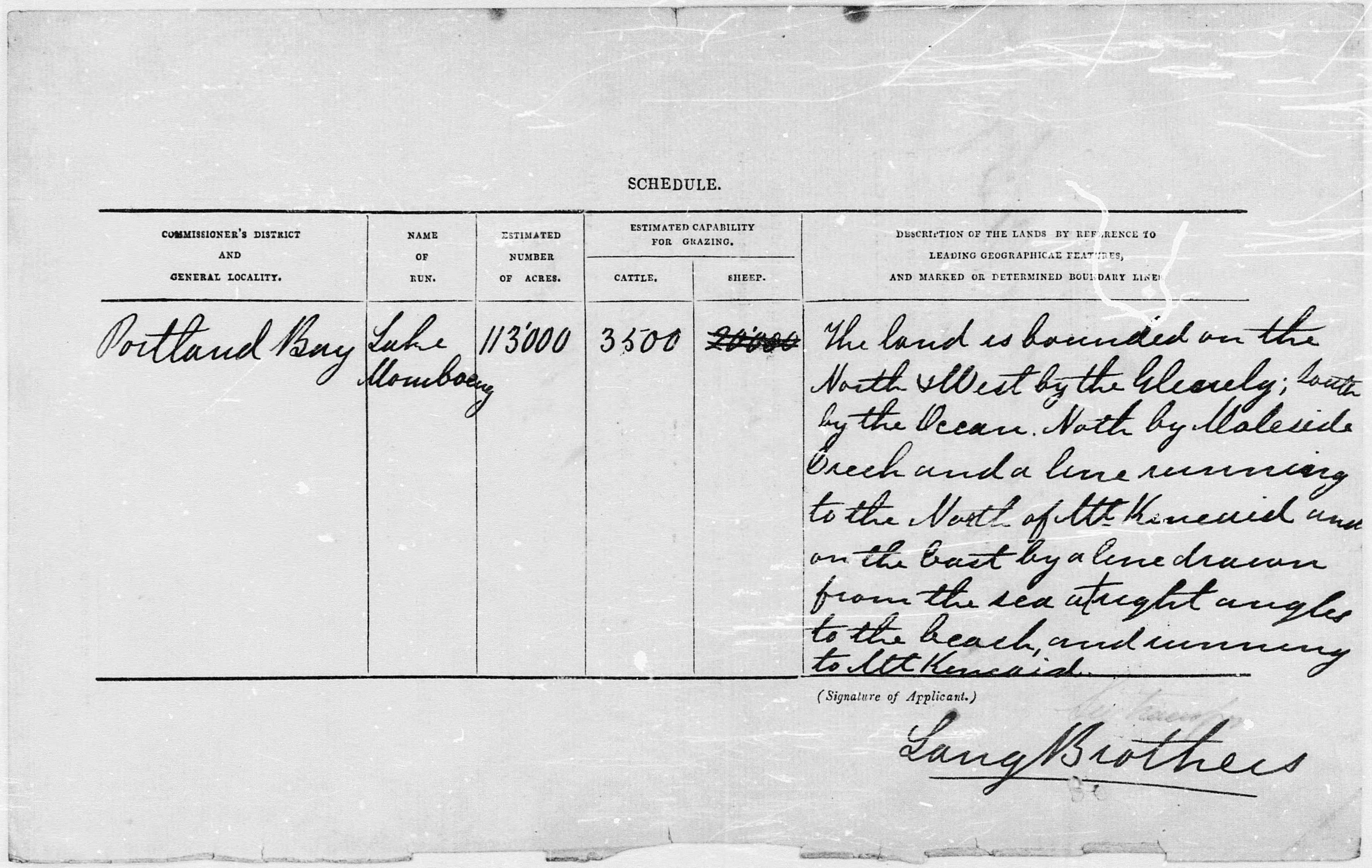
Page 2 of the form – “Schedule” – where Thomas Lang (who filled out this form) states the name of the run to be “Lake Momboeng”
As presented by the Langs themselves, we see the name as they intended it to be written. And it was repeated another three times by Thomas Lang in other documents in the file, as well as in document submitted by Gideon Lang a few months later (in April 1848) when he sought a separate licence (#160: Kentbruck) out of the eastern portion of the Lake Momboeng run.
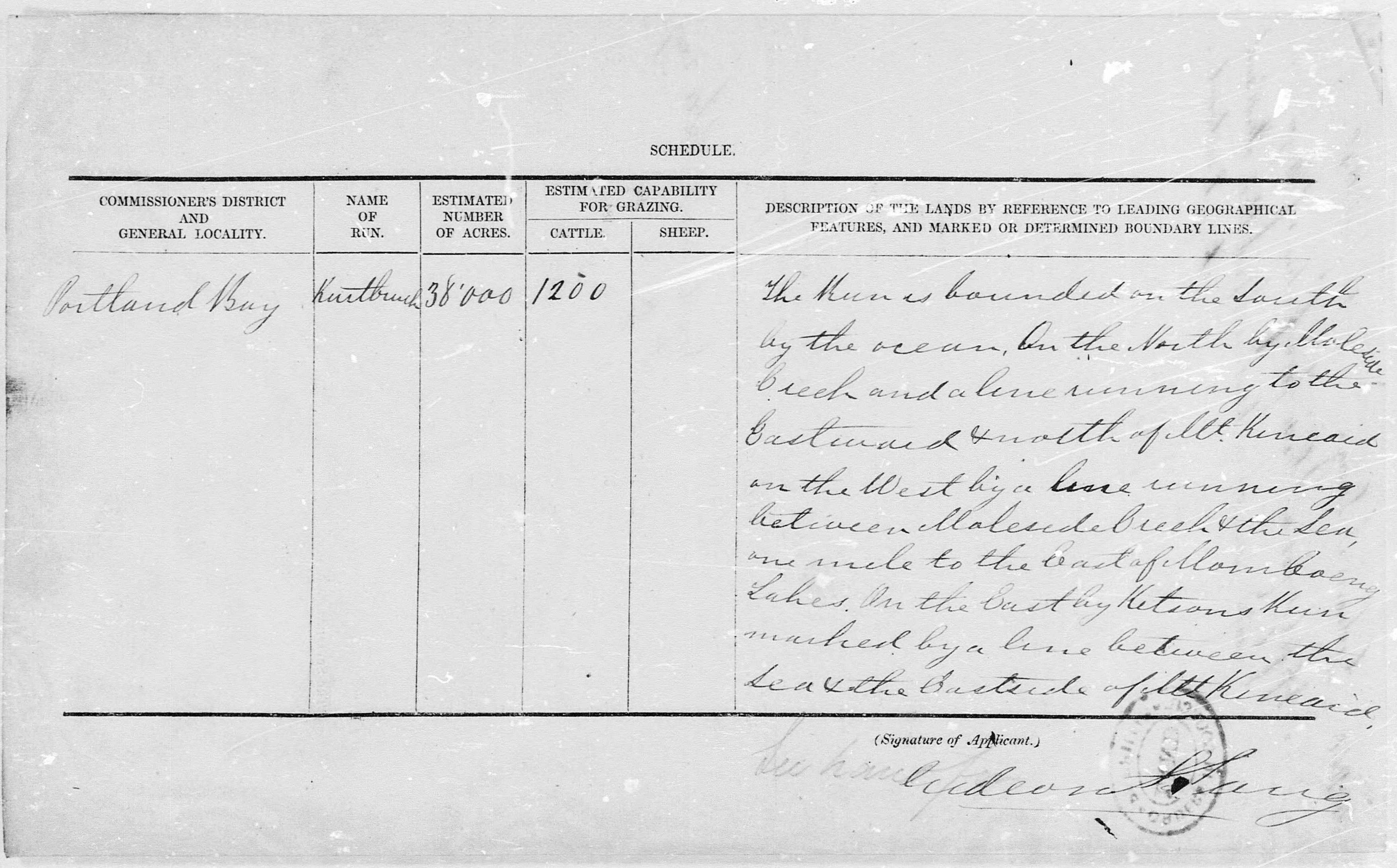
The Schedule on the back of Gideon Lang’s application to create the new run “Kentbruck” in April 1848, where he defines the boundary of the run by referencing the location of the “Momboeng Lakes”.
Yet, when the approved list of runs was eventually published in the Government Gazette for the first time, a year later (in March 1849), the spelling became “Moniboeng”.
Are you, like me, wondering how the name somehow appears to have immediately taken on another form?
The answer is a simple transcription error, caused by the heavy cursive writing style that makes up the majority of these early files. Indeed after looking through many of these files now, the inconsistencies are frequent. In the above publication you will also notice that Kentbruck had become “Kentbrush”, and Moleside Creek was referred to as “Maleside Creek”. As we’ve found repeatedly throughout this whole story, the spelling variations occur with surprising regularity, which may also reflect errors by the printing typesetter – who was no doubt rushing to do their job as quickly as possible. I just wasn’t expecting such variations to appear quite so quickly!
In fact, after looking through the early central register book kept by the Superintendent, Port Phillip District, to record transactions on the leases from 1848 until 1851, it is possibly to see the moment when this first error may have occurred (noting that after this date, Victoria became a separate State and began a new central register held by the new Crowns Lands Department).

What do you think, does this say “Momboeng” or “Moniboeng”? Is it conceivable that the dot that makes an “i” was an accident, or perhaps the officer preparing the list was rushed and didn’t look closely enough at the Lang’s handwriting? Interestingly, whoever was responsible for this mistake, also transcribed Kentbruck incorrectly to be “Kentbrush”, as shown. Both names were published in 1849 as shown above, copied into the new Register book in the early 1850s – and the rest is history!
And so, finally, we’ve finally been able to trace the game of ‘Chinese whispers’ back to its origin… between this central register and the first published run name being incorrect, the Langs moving on in late 1848 and the rapid displacement of the Indigenous people along Discovery Bay (the only people who truly knew how this name should sound), the inevitable arguments between the new local residents began.
To summarise, I think we can finally say – unequivocally – that the Lang Brothers intended to call their run Momboeng. Clearly that is why the Place Names Committee made the suggestion after reviewing these files in the early 1970s, and we’ve now seen the evidence here written in their own hand.
But is that the end of the story…?
Well – not quite… it turns out there is one more tantalising clue to be revealed from 1847, that predates the 1848 file. Stay tuned, as we’ll explore this in a future blog.