Reimagining the future of the wallan wallan wetlands – How historic information and modern tools can guide the restoration of burrung buluk (Hanna Swamp)
Although this story has been in the pipeline for the past few months, it is especially timely to finally be sharing it with you now, as so much of eastern Australia is currently experiencing flooding at a scale that the continent hasn’t seen in some time. If anything should encourage us to pause and consider how we interact with this land of extremes, it should be the sight of so many people sadly being forced from their homes as historic floodplains reactivate and remind us that nature cannot always be contained and controlled.
Background to Discussion Paper 3
It is against this salient backdrop that we encourage you to read and absorb this third discussion paper in our series on the wallan wallan wetlands, which is embedded a little later in this article. All three discussion papers can also be downloaded and viewed via these links:
- Discussion Paper 1: Restoration Vision for the wallan wallan Wetlands, including Herne Swamp, as the centrepiece of the wallan wallan Regional Park. March 2019.
- Discussion Paper 2: Achieving Integrated Water Management of the wallan wallan Wetlands – Recognising gaps, understanding systemic obstacles to adoption, and identifying solutions. July 2020.
- Discussion Paper 3: Reimagining the future of the wallan wallan wetlands – How historic information and modern tools can guide the restoration of burrung buluk.
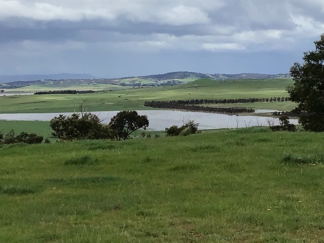
This time around, we continue our focus on burrung buluk (Hanna Swamp) which only a couple of weeks ago temporarily reappeared, as inflows (after intense rainfall in the surrounding landscape) were sufficient to temporarily overwhelm the artificial drains through the wetland basin which normally prevent this type of inundation (see here for a panoramic drone view from Green Hill, first of burrung buluk and then panning around to Herne Swamp).
With this context in mind, the image below of an inundated burrung buluk gives us a fascinating glimpse into the past and – subject to planning decisions to come – the potential future of this important landscape feature.
However, depending on the way those planning decisions play out, the potential future options for burrung buluk and how it will be treated are dramatically divergent.
Along one path, the wetland feature could face partial infilling and covering with urban infrastructure like roads and houses. This fate has befallen many former wetlands and floodplains within Melbourne’s urban environment, with acute consequences that continue to be felt by many residents who find themselves living in these developed areas now at risk of flooding. Even if former wetlands and floodplains themselves are engineered to reduce that risk locally, downstream areas are still inevitably impacted by increased volume, frequency, and flashiness of flows during flood events.

An alternative pathway could see the entire natural footprint of the wetland (along with an adequate buffer) retained, rehabilitated and integrated as a catchment asset within the future urban environment – noting that the bulk of the area immediately surrounding burrung buluk (pictured earlier) is also destined to become suburbs within Melbourne’s northern growth corridor. Creating the capacity to hold more water back in natural wetland features, reducing both the speed and peak volume of water reaching downstream areas, is an approach that would seek to work with nature and natural landforms, instead of fighting against it.
Subject to the eventual planning outcome for burrung buluk, this could set a new and improved precedent for the way that any wetland feature – either intact or degraded – is considered, assessed and treated across Melbourne’s urban growth areas in the future. At stake are not only a wide range of catchment management and environmental outcomes, but also the flood risk and liveability of future suburbs for the communities that will call these places home.
Understanding key drivers in the planning and development system in Victoria
While a 60 hectare wetland feature is not especially large in a rural context, in an area designated for future urbanisation, this represents a large zone that would need to be permanently set aside as open space. Despite a very long list of self-evident benefits associated with retaining this feature as open space for future residents and as a waterway asset, such a decision would carry a high short-term opportunity cost, in economic terms, for those who would otherwise benefit from its infilling and development.
An earlier Planning Panel decision in 2020 required the various parties with an interest in the area to look more closely at and consider burrung buluk in future plans. As a result, large amounts of money are being spent on consultants, as the main players seek expert advice to justify, support or challenge each other’s positions. Many of these consultants are also paid by their clients to appear before planning hearings as expert witnesses.
But what are the constraints and limitations of this highly adversarial system?
The current structure of the development system in Victoria strongly incentivises private speculation in land ownership and the maximisation of developable area within private land zoned and designated for urban growth. This is the underlying driver for the majority of the most active players who participate in this system. However, a system that is so strongly adversarial in nature, with a great deal financially at stake for the ‘winners and losers’, brings with it risks in the way that information is portrayed and the tactics that are employed.
The result is a system that feels more like a legal process, where the portrayal of information relevant to planning decisions is influenced by who has the time, ability and means to be present – and hence have a voice – to influence those decisions. This is because planning hearings are often weeks-long processes that run through regular business hours, meaning that most people who are not being paid for their time (or cannot afford to make the time) to be involved are inadvertently excluded. By way of example, it is clear that if not for a submission by the Friends of Merri Creek in 2020, a volunteer community group, burrung buluk would otherwise have been completely overlooked by those who were professionally engaged to assess this area ahead of urbanisation.
A further unfortunate side-effect of the way the system currently functions is that collaborative problem-solving between multiple parties to resolve, discuss or seek common ground around complex matters ahead of formal hearings is not generally encouraged or facilitated. Decisions are made and positions are taken by various parties behind closed doors, and then strongly defended, sometimes despite compelling evidence to the contrary.
This approach is unfortunate, because it prevents the discussion of nuanced, complex topics and the workshopping of alternative approaches to issues like those confronting a waterway feature such as burrung buluk. The adversarial approach tends to stifle cooperation, creativity and the general atmosphere required to find or co-design solutions.
Improving eco-hydrological literacy and the information available to support planning decisions that impact waterways and wetlands
In this third discussion paper we aim to highlight and share the type of key information that is not typically assembled, shared or presented by the main participants in the planning system for their own use, nor for consideration by decision makers. If it were made available, this is the type of material that is capable of supporting more sophisticated analysis, discussion and planning decisions relevant to wetlands and waterways, especially those that are modified as a result of prior land use but retain restoration, rehabilitation and/or catchment management potential.
You can download the pdf of Discussion Paper #3 here, or view it below.
It is a solid read, so please make yourself a cuppa before you start!
Nature Glenelg Trust is committed to making complex environmental science more accessible and available to decision makers and the general public, for community and environmental benefit. In this spirit of constructive dialogue, feedback or questions in relation to this discussion paper are most welcome.
You can contact me directly by email (), or anyone else in the NGT team via