The Rowan Swamp Restoration Trial (Vic) gets underway just in time for winter 2022 flows!
Rowan Swamp hasn’t yet featured in our monthly email newsletter, but over the past 18 months Nature Glenelg Trust has been busy undertaking an independent eco-hydrological assessment of the Rowan Swamp Wildlife Reserve, in partnership with Parks Victoria. Rowan Swamp is an approximately 150 hectare wetland feature, situated near the township of Lake Rowan, in the Goulburn Broken CMA region about 40km north of Benalla.
The process of getting to know this site has involved an investigation of the history of the wetland and the changes that have occurred to its hydrology (i.e. water regime) since European colonisation. The information that we have been assembling and analysing has been shared with local community members and landholders in a series of email updates.
A brief summary of key findings so far
- Rowan Swamp is an instream wetland of Boosey Creek, a waterway which enters the swamp from the south-east, and starts up again as a defined channel along the northern edge of the swamp.
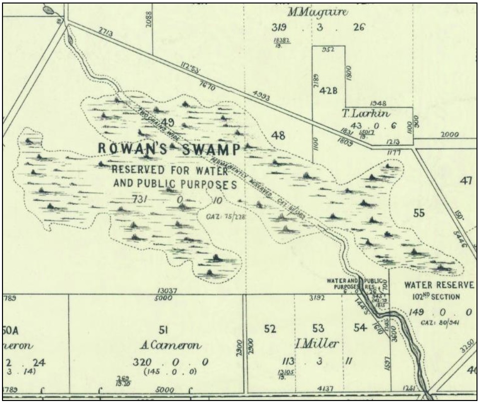
- Rowan Swamp was set aside early, as reserved public land in the late 1800s (on the map from 1883 shown above, it says it was “Reserved for Water and Public Purposes”).
- The two-chain drainage reserve set aside across Rowan Swamp (shown above) was never used to construct an artificial channel across the wetland, so the wetland fills to varying degrees whenever there is a flow in the creek.
- Despite being reserved, the swamp appears to have been subject to grazing leases or licences for most of its post-European history, which (in the absence of the traditional cultural use of fire in this landscape since colonisation) has likely played a role in maintaining its open grassy woodland character.
- Exotic pasture grass (Phalaris) was introduced into the Boosey Creek catchment several decades ago, probably during the soil conservation works era, and resulted in the eventual arrival of this species in the reserve a few decades ago. Over the past 30 years, the gradual expansion of this species has occurred across a significant part of the eastern portion of the reserve, and threatens its biodiversity values.
- Changes in rainfall patterns and land use over recent decades have reduced the frequency of flows into Boosey Creek, resulting in less frequent inundation of Rowan Swamp.
- Major erosion events, which likely occurred between the late 1800s and early-mid 1900s have altered the physical character of Boosey Creek, including reducing the depth of permanent pools along its length (resulting in the creek losing its ‘chain of ponds’ character), as well as the deepening and extension of eroded channels associated with the creek inlet to, and outlet from, Rowan Swamp.
- The various changes described above have resulted in the loss of many native species previously observed in and around Rowan Swamp, and during dry times, the once permanent pools of Boosey Creek.
- The outlet from Rowan Swamp (where Boosey Creek recommences) has now migrated (via erosion) a significant distance upstream to the south, where it has breached the former edge of the wetland, reducing its capacity to hold water after a flow event. This impact has been amplified by what have become less frequent flows over time, and those flows have typically been of shorter duration.
Designing a restoration trial for Rowan Swamp
Given the above background, our investigation identified that the site would respond favourably to a restoration trial. The trial would be capable of reversing the detrimental impacts of outlet erosion, by enabling any flows that do reach the swamp to be retained to the natural depth (that is, the original cease-to-flow, full supply level) of the wetland for a longer duration. This predicted extension in inundation period after each flow event will have a wide range of benefits for the flora and fauna within the reserve, including their recruitment and breeding life cycles.
Location of the restoration trial structure
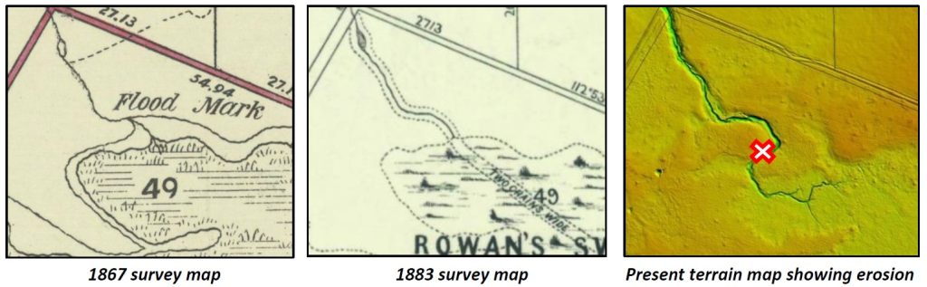
The most suitable location determined for the installation of a trial structure was at the location where the edge of the wetland was mapped in plans drawn in 1867 and 1883, as shown below. Also shown below is the significant erosion and migration of the creek channel in the modern digital elevation mapping, compared to the location of the waterway in the 1800s.
Determining the height of the restoration trial structure
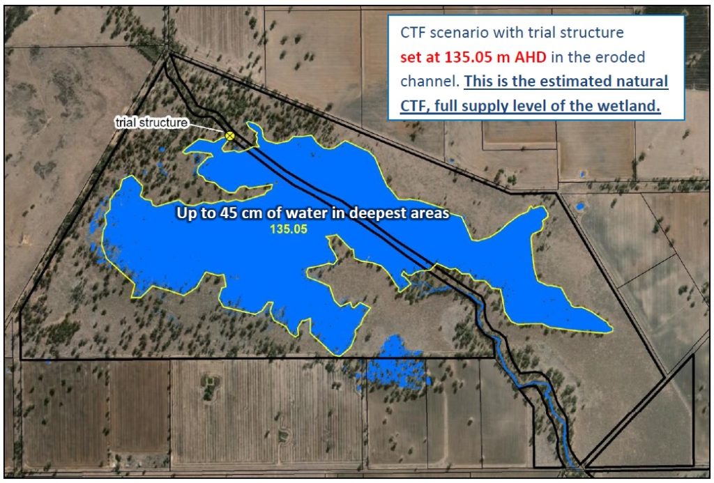
Using modern (LiDAR) technology to look at surface elevations through the reserve, combined with information about the location of the creek and the mapped extent of the wetland in 1867 and 1883, we have been able to ascertain that the natural cease-to-flow (CTF), full supply level for the wetland is approximately 135.05m AHD (i.e. above sea level). This scenario is shown below, and results in a wetland extent that matches the 1883 map shown above.
This means that after each Boosey Creek flow event:
- Rowan Swamp will fill until there is roughly 45cm of water in the wetland in its deepest areas, at which time the outlet will activate and flows will continue to flow downstream. Note that the wetland already reaches this depth on occasions, but due to erosion the outlet activates well below this level and reduces the duration of inundation.
- Rowan Swamp will continue to hold this depth of water in the swamp after inflows reduce, because the outlet will cease-to-flow at this level.
- Rowan Swamp will then more slowly dry down from the new retained CTF level, via evapo-transpiration and infiltration, providing extra time for wetland plants and animals to complete their life cycles and take advantage of this improvement in wetland condition.
Construction of the trial
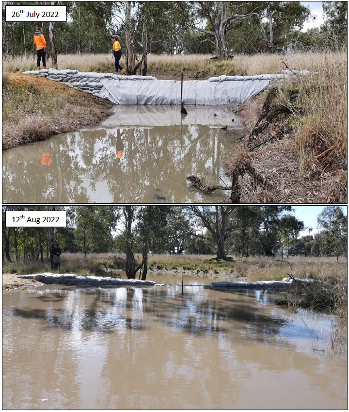
On the 25th and 26th July 2022, a team comprised of NGT staff, the Woka Walla crew (from the Yorta Yorta Nation Aboriginal Corporation) and local volunteers, completed the structure by hand to our design specifications.
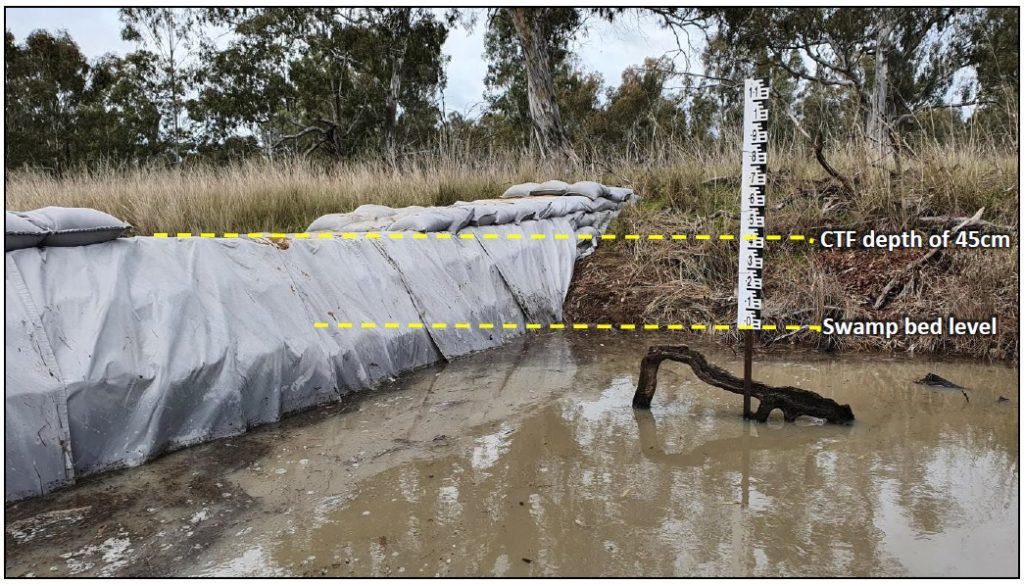
To make it easier to keep track what is going on in the swamp, we have placed a gauge board in the channel immediately upstream of the structure (next to some Red Gum roots now exposed due to erosion). As shown below, the 0 cm level of the gauge board corresponds to the bed level of Rowan Swamp upstream, while the spillway cease-to-flow (CTF) level has been set 45 cm above this level (at 135.05 m AHD).
We didn’t have to wait for long for flows to arrive!
In a fortuitous quirk of timing, a couple of rainfall events in the Boosey Creek catchment in the two weeks after the structure was completed generated sufficient flows to fill Rowan Swamp to the new spillway depth. So we didn’t have to wait long to see the results! Click through the pages of the pdf images below to see before and after images of the structure, from an oblique view, and directly above.
Above-view-Rowan-Swamp
In the image above, note the Red Gum roots, protruding in the bed of the channel as a result of erosion, which are now almost all invisible with the reinstatement of water levels to near natural surface at the swamp margin. Further upstream, as the eroded channel becomes more shallow, the same process has occurred – with the exposed Red Gum roots that were once below natural surface at this location shown below.
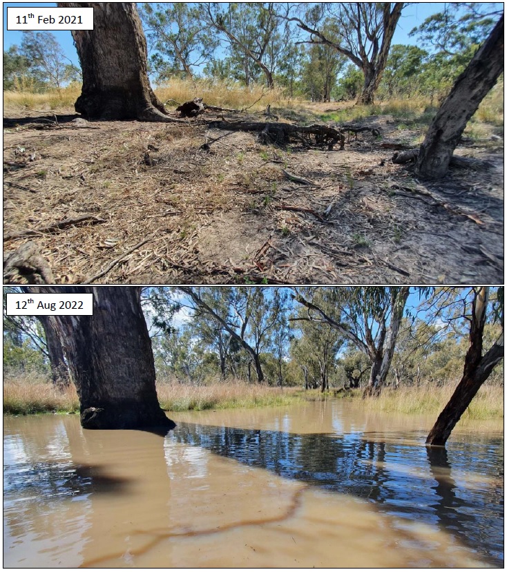
Under the influence of the trial structure, this section of eroded channel is now once again situated within the northern margin of the swamp, experiencing shallow, static inundation over natural surface. Wetland restoration works like those completed at Rowan Swamp help us to take the energy out of flows and eliminate its erosion potential, as shown above.
Meanwhile, in the centre of the swamp, the recent inundation is triggering an explosion of wetland life, which will now have the benefit of water levels remaining more stable over the weeks (and possibly months) ahead, giving these species a better opportunity to complete their life cycles before the wetland begins to dry down (subject to rainfall) over the coming spring or summer .
All in all, we have a very interesting time of observation coming up for this very special wetland!

Some acknowledgements
A big thank you so far to the many local landholders and community members who have shared their knowledge of the site and for working with us as this project has progressed towards the restoration trial phase. We really appreciate your interest and support in this important work.
A special thanks also to the NGT, Woka Wolla and volunteer crew who put in a couple of big days doing the manual work on the trial structure, and to Parks Victoria, the Goulburn Broken CMA and the Yorta Yorta Nation Traditional Owners for supporting the project over the past two years and for providing the necessary approvals ahead of the works. Finally, thanks also to the Australian Government, our most recent partner in the implementation phase of this project, via the Murray–Darling Healthy Rivers Program.
This project is supported by Nature Glenelg Trust, through funding from the Australian Government’s Murray–Darling Healthy Rivers Program and Parks Victoria.