Uncovering the hidden history of the Hutt Bay wetlands prior to the first aerial photography in 1945
As NGT’s ‘Recharge Farms’ project (which has been supported by the Limestone Coast Landscape Board for the past 15 months) comes to a close, we have been busy compiling all of the relevant information for the Hutt Bay wetlands into the management and restoration plan for this NGT Reserve. This important document will underpin our approach to caring for this recovering wetland area and the adjacent coastal zone over the years and decades ahead.
As long-term readers of NGT’s newsletter will know, when we work on a restoration project we usually try to do a bit of digging, to uncover what we can about the history of change at a site. Gaining an insight into the timing, nature and intent of changes that have been made in the past can help inform restoration planning and sequencing of actions today. It can also better define the potential goal-state of restoration works, by providing clues as to what a site looked like and how it functioned (especially in relation to water level and flows) before it was modified.
Oh yes, and what we learn is also often pretty fascinating as well!
It turns out that Hutt Bay is no different, and we’ll share a bit of that that history with you here. Before we start however, I would also like to acknowledge Tayler Price, a student from the University of Adelaide who recently completed her 3rd year work placement internship with NGT. Tayler uncovered some of the key documents from the archives in Adelaide, especially from the early-mid 1900s, that have helped us to complete the picture for the Hutt Bay wetlands. So thank you Tayler!
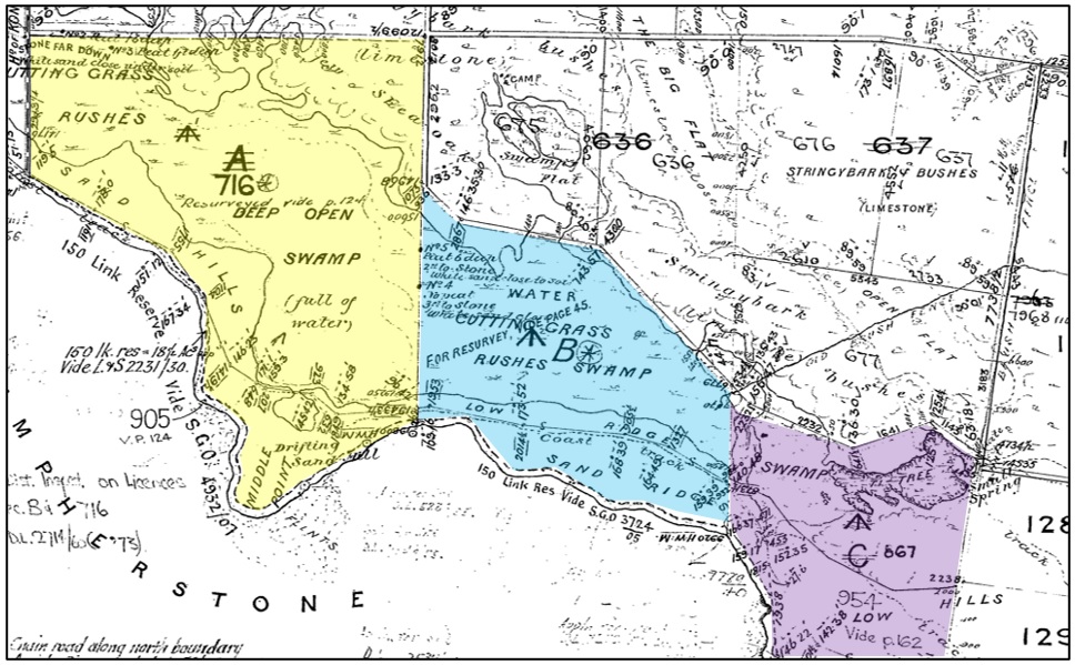
We’re going to pick up the history of the Hutt Bay wetlands in 1880, when the wider Middle Point Wetland area was first surveyed in detail and divided into three crown land parcels, Sections A, B and C, as shown below. For reference, the present-day NGT reserve is comprised of Section B and part of Section C.
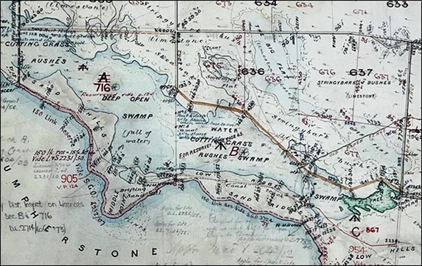
In terms of providing clues as to the original character of the wetland, this detailed survey diagram is incredibly helpful. Not only does it indicate in relatively fine detail the original extent of the wetland in its un-drained state, but it also provides some understanding of the broad vegetation communities present in and around the wetland at that time. For example:
• Consistent with many early descriptions of the coast (including dating back to both Flinders’ and Baudin’s observations in 1802, long prior to the arrival of livestock or rabbits), the dunes were observed to either be lightly vegetated or bare, drifting and open in many locations along the South East coast – providing an indication of their state when occupied and utilised heavily by Bunganditj people living traditionally (and shaping the physical and ecological character of the dunes through the requirements of everyday life and cultural practices).
• The fresh groundwater-fed area of dense ‘ti-tree’ scrub is marked in green at the eastern end of the wetland, along with a small spring feature near its edge.
• The bulk of the rest of the swamp is noted to consist of cutting grass and rushes, with the deepest areas full of open water.
• To the north of the wetland there are intervening open flats and areas of stringybark or sheoak woodland over shallow soils with outcropping limestone.
• With the wetland apparently near to full and its extent apparent (to a much greater degree than today), a point where the wetland extends almost right through to the coast at the eastern end (in the location of one of the modern artificial drainage outlets) is suggestive of a possible seasonal outlet that might activate when wetland levels were high enough.
• Finally, it is also clear that the wetland didn’t finish at western side of Section A – indicating that this area was part of a larger coastal wetland system.
Just how large that wider wetland system was, is shown in the image below.
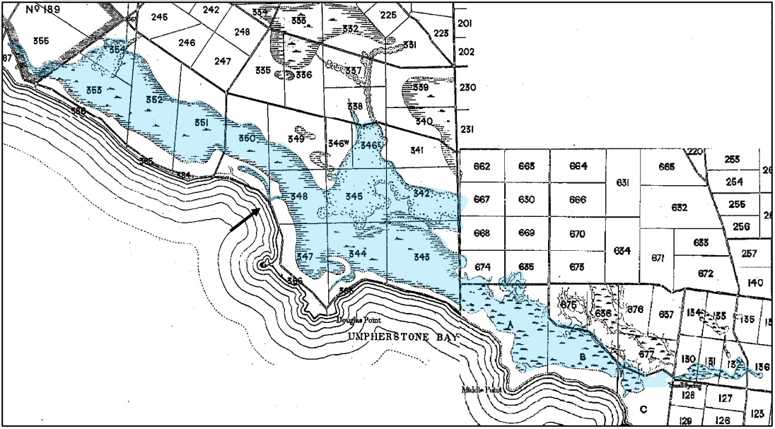
This continuous band of near-coastal wetlands shown here, known historically as Big Swamp, extended all the way from present day Nene Valley in the west, to Cape Northumberland in the east – with the coastal township of Port MacDonnell just off this image further west (right). The main permanently running outlet mapped in the 1880s is shown above with a black arrow, with the whole expanse fed by dozens of permanent discharging springs from the shallow unconfined aquifer, supplemented by seasonal rainfall and surface flows. It was an amazing, vast area that was targeted for development in the decades following this subdivision.
To help explain that trend of development of the Middle Point Wetland, including NGT’s wetland reserve at Hutt Bay, I’ve pulled together the follow summary of the early tenure history of Sections A, B and C, as follows:
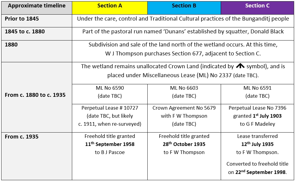
This understanding of the tenure history of the Middle Point Wetland provides potentially important clues to the history of development of the wetland, in particular clearance of native vegetation and artificial drainage which occurred prior to the first aerial photography in 1945, as shown below.
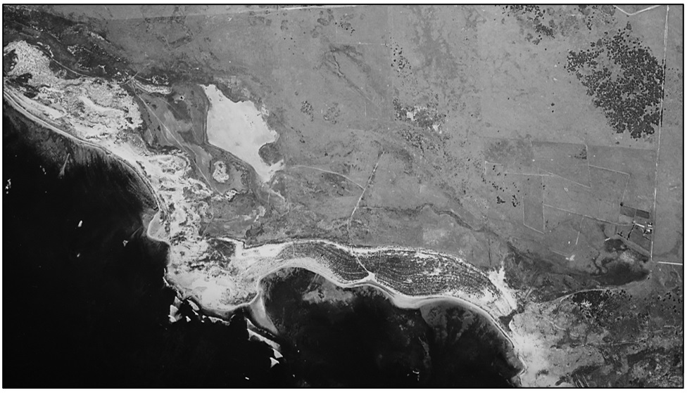
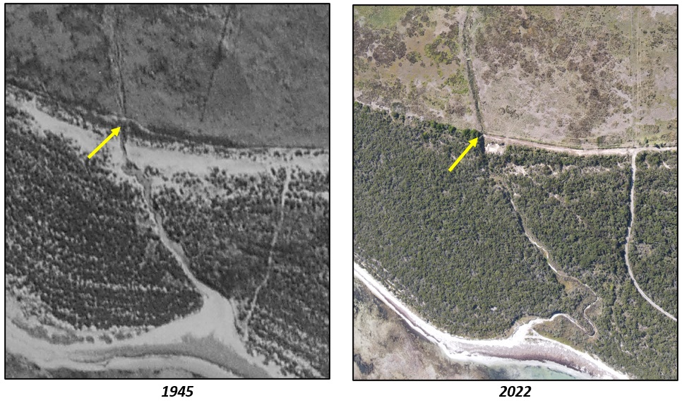
By zooming in, we can clearly see that the wetland had already been extensively cleared and drained before 1945, via the two artificial outlets shown below.
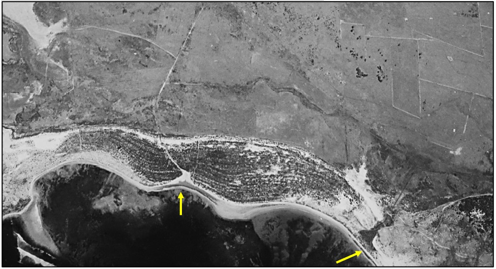
Based on assessment of the aerial imagery alone, the western outlet is very clearly a newer artificial cutting through the dunes, however the appearance of the outlet at the eastern end, is more suggestive of being a natural feature that may have existed in some form prior to being formalised as a terminus for artificial drainage.
Indeed, when the 1880 survey plan is cross-referenced with the primary source data upon which it is based (Field Book No 1131, Hundred of MacDonnell, 24th June 1879 to 15th December 1880), this evidence of the eastern outlet potentially being a natural point of occasional overflow to the sea becomes more compelling, as shown below.
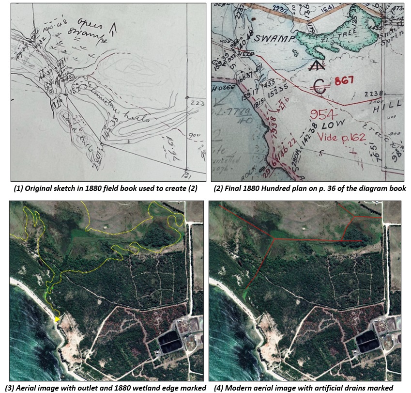
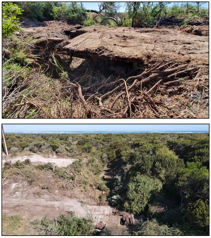
As shown above in images 1 and 2, comparing the original sketch with the finalised plan, clearly shows that more accurate and detailed topographic information is available in the field sketch. It is this detail that is highly suggestive of a recently active pathway being present for seasonal or episodic overflow from the wetland to the sea, when full. Images 3 and 4 show how the location of these features on the ground today supports this hypothesis, and also illustrate how artificial drainage activities often took advantage of any existing natural places where flows might occur, by deepening and formalising them. Before modern excavation equipment, this approach considerably reduced the amount of manual work and cost involved in artificially draining land.
Possible reasons for a seasonal or episodic outlet not being marked, even if it were present at this location, include:
- a lack of flows or ponding in the channel at the time of the survey,
- summer sand accumulation on the beach and dune forming processes closing over its mouth, and
- the fact that a minor outlet that only activates in extreme events may not run regularly, for long periods of time or even every year.
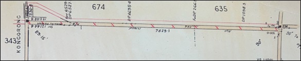
Further evidence that this may have been a natural outlet can be inferred from some interesting information recorded on a map dated 2nd August 1915, from the files created for a “Petition drain near Cape Douglas”. This is a time when comprehensive and coordinated artificial drainage of the entire coastal portion of the Big Swamp wetland complex (including the Middle Point Wetland) appears to have been first proposed by farmers around Cape Douglas, as shown below. The petitioners’ properties are bounded by the pink line.

Not only are the proposed drains marked, but there are a series of notations, from A to F, along the coast to indicate where existing or possible future drainage outlets might be located. A and B are the eastern and western drain outlets from the Hutt Bay wetlands today, while Outlet E (Black’s Creek) and Outlet F were the only running natural outlets mapped in the 1880s. Interestingly, the map notation at location A, says “Existing outlet about 5 feet wide, choked, liable to obstruction“.
By 1915, it seems that three of the six outlets (A, D and E) were active in some way, likely enhanced by human intervention, and by 1945, all of the outlets marked above had been formalised into drains, except for Outlet F, which appears to have become blocked by drifting sand prior to 1915. Even though the drain cuttings to the sea had been made, it is clear from the 1945 aerial imagery shared earlier that comprehensive drainage based on the 1915 petition never proceeded, because by that time only the Middle Point Wetland portion of the Big Swamp complex is fully drained and cleared. The central portion of the Big Swamp complex was drained over subsequent decades, and the western portion of the complex (Nene Valley wetland) was the last to be fully drained in the early 1980s, when an additional ocean outlet was cut through the dunes west of location F.
Based on the appearance of the Middle Point Wetland in 1945, there remained gaps in our knowledge of land use and drainage over the decades prior, leading up to this time. Although the state government records searched so far from that era did not shed any light on the precise timing and nature of the drainage works that can be seen in the 1945 image, there are other clues available in the newspaper records of that era, which are able to be cross-referenced with other data to help narrow this down.
Firstly, in terms of the eastern artificial outlet through Section C:
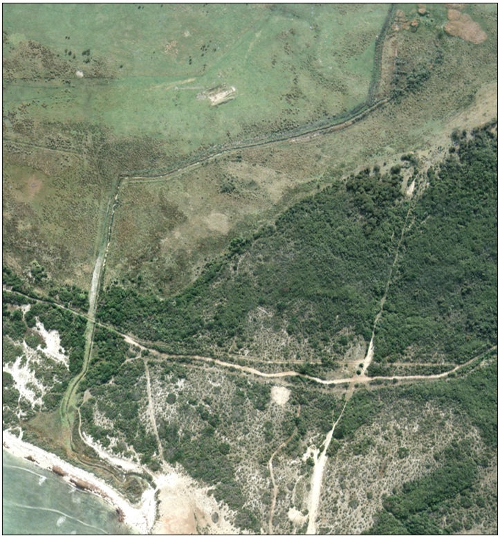
• We know from the information recorded on the 1915 map that this eastern outlet was already functioning in some capacity at that time, although it is unclear how it had been modified. For a more modern view of this area, a 1995 image is shown below.
• It would appear from the drainage plans drawn in 1915, that a drain had probably not yet been constructed from the outlet to the patch of spring fed tea-tree at the eastern end of the Hutt Bay Wetland, at least certainly not to its modern specifications.
• We also have the following information from the records of a meeting by the Port MacDonnell Council, in the Border Watch on the 8th of August 1935, only a month after Fred Thompson (you can read more about Fred Thompson in this story) secured the lease to Section C from Mr Madeley:
“Mr. F. Thompson wrote applying for permission to open an old drain from what was known as Madeley’s ti-tree to the sea. He had a drain half a mile further west, but it would not dry this block. Granted on the motion of Cr. Pascoe, seconded by Cr. Kemp.”
• If the drain was considered ‘old’ in 1935, then it seems plausible, indeed likely, that Mr Madeley constructed this drain not long after the 1915 petition, but did not maintain it.
• The other key item of information here, is the reference to a “drain further west” which confirms that the western artificial drainage outlet through Section B had also been constructed by this time.
Secondly and further, in relation to the western artificial drainage outlet through Section B:
• Ten years earlier, on 5th May 1925 in the Border Watch it was reported that Fred Thompson had made a deputation to the Port MacDonnell Council.
• The article states that:
“Mr. F. Thompson waited on the Council in regard to the road running along the coast in the direction of Cape Douglas, adjacent to his land. With the permission of this Council he had improved his land considerably by cutting a drain through it to the sea, and had promised to erect a bridge over the drain where it crossed the road. He was keeping to his agreement, but, as he pointed out, the road was impassable to traffic and would be so much money thrown away. He asked if the Council would rather have him erect the bridge in any other place. If the Council wished to construct a new road he was willing to sell them the land.”
• Now if we combine this information with the tenure information in the Table earlier in the article, we can see that the only coastal land Fred Thompson leased in 1925 was Section B, as Section C was still leased by Mr. Madeley at that time. This allows us to narrow down the works location and accurately date the construction of the western outlet from the wetland.
• Those works most likely occurred in early 1925 or in the years prior, and the construction of the bridge likely followed soon after (note that Council did not approve moving the road).
• The location where the drain and road intersected in 1945, 20 years later, and what remains of the bridge today, almost 100 years later, are shown below.
Thirdly, in 1938, efforts led by Port MacDonnell Councillor W. H. Pascoe, led to the pursuit of more comprehensive drainage of the land around Cape Douglas – seemingly inspired by the comprehensive drainage works being embarked upon in the Eight Mile Creek Swamp (east of Port MacDonnell), led by government. This was seen as necessary, because despite the drainage and clearance of the bulk of the Middle Point Wetland likely occurring in the 1920s and 1930s, the bulk of the Big Swamp wetland complex to the east was not significantly developed by this time, as evidenced by the aerial photographic records of this area several years later in 1945.
As far as can be seen from the records around that time:
• Initially an attempt was made at the beginning of 1938 to have the Department of Lands take responsibility for drainage, but this was rejected on the basis that much of the land was already under freehold title, and fell outside the declared South Eastern Drainage District and therefore was also not the responsibility of the Drainage Board (Department of Lands File No 229 / 1938).
• When this attempt failed, later in the year in June 1938, Councillor W H Pascoe notified the Port MacDonnell Council:
“that it was his intention of convening a meeting of all landowners interested in the drainage of their land in the district, with the object of bringing the land under the jurisdiction of the S.E. Drainage Board. This, he stated, would solve the drainage problem from Cape Douglas to the Glenelg River.”
• However, it was reported in the Border Watch on 12th January 1939, that a larger group of ratepayers – fearing a cost imposition on their land to fund a wider scheme – petitioned the Port MacDonnell Council at their meeting objecting to the proposal. In response at the meeting, Councillor Pascoe said:
“there was a misconception of the whole thing. It was a strong petition and the original request came from the Cape Douglas area. Dry land owners were never expected to pay for the work. However, he was prepared to with-draw with the permission of his seconder.”
• At that point the discussion of possible comprehensive wider drainage in the late 1930s ends, taking us through the era of change we can detect via aerial imagery.
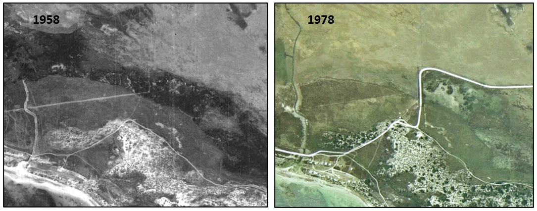
Finally, the only other alteration to drainage after that time was the creation of the modern road to Cape Douglas and installation of the culverts which continues to act a final point of drainage regulation between the Middle Point Wetland and the rest of the now drained Big Swamp wetland complex to the west. The road in its current location, around the northern end of Section 716 (originally Section A) was surveyed c. 1960 (see image below). This change in alignment was to allow for the road to be built around a deep wet area at the western tip of the present-day Middle Point Wetland. Anyone who travels to Cape Douglas regularly today will know this bend in the road well!
The construction of the new road and culvert, and its effect on the hydrology of this part of the wetland, by creating a point of east-west demarcation in development of the present-day Middle Point Wetland, is evident from the aerial photographic record shown below.
In summary, based on the presently available information assembled here, it appears that:
• The Middle Point Wetland was the first portion of the wider Big Swamp wetland complex to be comprehensively drained, with two drainage outlets (including one that may have been natural but modified) created on land that forms the present-day Hutt Bay Restoration Reserve.
• The eastern outlet may have been natural and carry intermittent flows when the wetland was full, but was probably made the terminus for more formal artificial drainage of the tea-tree spring c. 1915, by the lessee at that time, Mr. Madeley. To create the necessary gradient for artificial drainage below the natural sill level, those works required making a significant cutting, approximately 2 metres deep, through a reef of limestone bedrock at the edge of the wetland (next to the present-day track crossing). Those works were enhanced c. 1935 by Fred Thompson.
• The western outlet was constructed by Fred Thompson c. 1925.
• This sequence of events led to the change in appearance and condition of the wetland between the time of the earliest survey diagrams in 1880, until aerial imagery was first flown in 1945.
• Later changes to the hydrology of the western end of the present-day Middle Point Wetland – including an east-west demarcation point for drainage – were formalised by the creation of the present-day Cape Douglas Road (and its culvert) in the 1960s.
I think that will do for our trip into the past today, but if you are interested to learn more about the history of the Hutt Bay wetlands directly from the family that previously farmed this area, please read this article by Robert Thompson from a few years ago, which shares the story of the site (and his forebears).
By the way, if I get a chance to revisit this topic, next time we’ll take a closer look at how the wetland has changed since 1945… so watch this space!
The project is supported by the Limestone Coast Landscape Board, through funding from the South Australian Government’s Landscape Priorities Fund and the Australian Government’s National Water Grid Connections Funding Pathway.