To burn or not to burn? At Lake Hawdon South, that is the question…
At the recent NGT workshop in Dunkeld, I spoke to other NGT staff about some of the special attributes and unique management challenges associated with Lake Hawdon South, one of the largest (3,200 ha) and most intact wetlands in the South East of SA. To give you a sense of what was discussed, this is an abbreviated version of that talk…
Lake Hawdon South supports a suite of ecological values of national environmental significance including populations of Australasian bittern, little galaxias and a diverse and abundant community of migratory shorebirds. Other significant fauna include glossy ibis, southern emu-wren and the enigmatic Australian mudfish, for which the wetland is a major stronghold. A unique formation of thrombolites also occupies approximately 300 ha of the reserve. The water regime is reliably seasonal, with a maximum depth of approximately 1 metre, and the salinity is fresh-brackish.
Livestock grazing was introduced to the Lake Hawdon area from the 1840s. It is likely that fire was used to the open up the dense Gahnia filum tussock vegetation and create green pick on the wetland bed for livestock. In the early 2000s large areas of Lake Hawdon South were being burned, in most years, for this purpose. At this time, concern about the combined impact of regular burning and grazing upon the ecological values of the area led to a push for its inclusion into the reserve system. The then Department for Environment and Heritage took action and grazing ceased in May 2009, with Lake Hawdon South Conservation Park proclaimed in 2010. Without a grazing licensee to manage it, regular burning of the wetland effectively ceased at the same time. The management regime changed dramatically from grazing with regular, probably annual, burning to a new combination of both no grazing and no burning.
Prior to proclamation it was clear that cessation of grazing posed risks for the wetland. Of chief concern was the potential proliferation of swamp paperbark, Melaleuca halmaturorum. Grazing exclosures established throughout the Lake Hawdon area in the 1980s showed clearly that without grazing, open wetland areas could readily convert to Melaleuca thickets.

Grazing exclosure (left) on Lake Hawdon North compared to grazed control (right) in 2002, approximately 20 years after establishment.
Such a change had the potential to dramatically change the ecological character of the wetland and exclude species favouring open, shallow mudflat habitats, such as migratory shorebirds and other waders. Clearly, grazing was playing a role in preventing Melaleuca dominance. So why hadn’t Lake Hawdon been covered in Melaleuca prior to the introduction of livestock? Probably because it was regularly flooded much more deeply and for longer periods than is the case today. Historically, Melaleuca halmaturorum was confined to the wetland margins, and large, old specimens still occupy the margins of Lake Hawdon North. Regional drainage, particularly the construction of Drain L through the bed of Lake Hawdon North, greatly reduced the typical depth and duration of inundation throughout Lake Hawdon, North and South. This change greatly increased the risk of Melaleuca invasion and dominance across the entire wetland bed. Melaleuca seedlings drown after a few weeks of complete submersion, but with shallower inundation, complete submersion of seedlings became less likely.
With these concerns in mind, a vegetation monitoring program was established in 2008, in anticipation of the cessation of grazing at Lake Hawdon South. Counts of Melaleuca halmaturorum seedlings were taken every year up to 2016. The results show very clearly that Melaleuca is increasing rapidly in Lake Hawdon South and there is a very real threat of the species displacing other vegetation types.
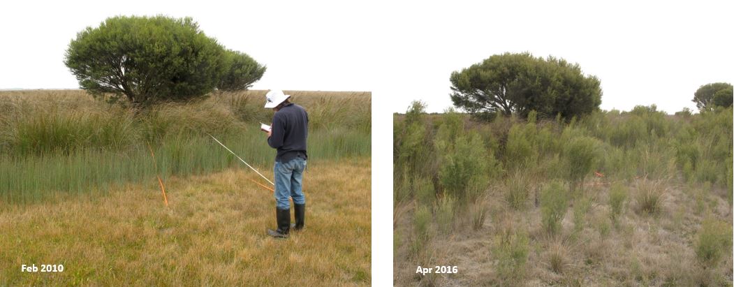
The late and dearly missed Steve Clarke undertaking Melaleuca monitoring at Lake Hawdon South in 2010 (left) and the same location in 2016 (right) showing a dramatic increase in Melaleuca abundance.
Although fire can kill adult Melaleuca shrubs, burning a dense stand of Melaleuca can stimulate a mass germination event. Also, larger Melaleuca often resprout from the base following fire. So while fire can be a useful tool in controlling Melaleuca, it needs to be regular enough to prevent dense stands of Melaleuca from establishing in the first place. Once dense stands of older Melaleuca are established in wetlands it is likely to be very difficult and costly to convert such areas back to open wetland habitat. It is a definitely a case of prevention is better than cure.
In April 2018, the Department for Environment and Water undertook the first burn of Lake Hawdon South in over 10 years. Approximately 350 ha, or around 10% of the reserve, was burned.

Prescribed burn at Lake Hawdon South, 26th April 2018 (photo Ross Anderson, DEW)
By December 2018, following good seasonal flooding in winter and spring, the wetland vegetation in the burned area was regenerating well. Encouragingly, a lot of small to medium sized Melaleuca halmaturorum shrubs were dead and there appeared to be little to no regeneration of Melaleuca seedlings around them or resprouting from the base.
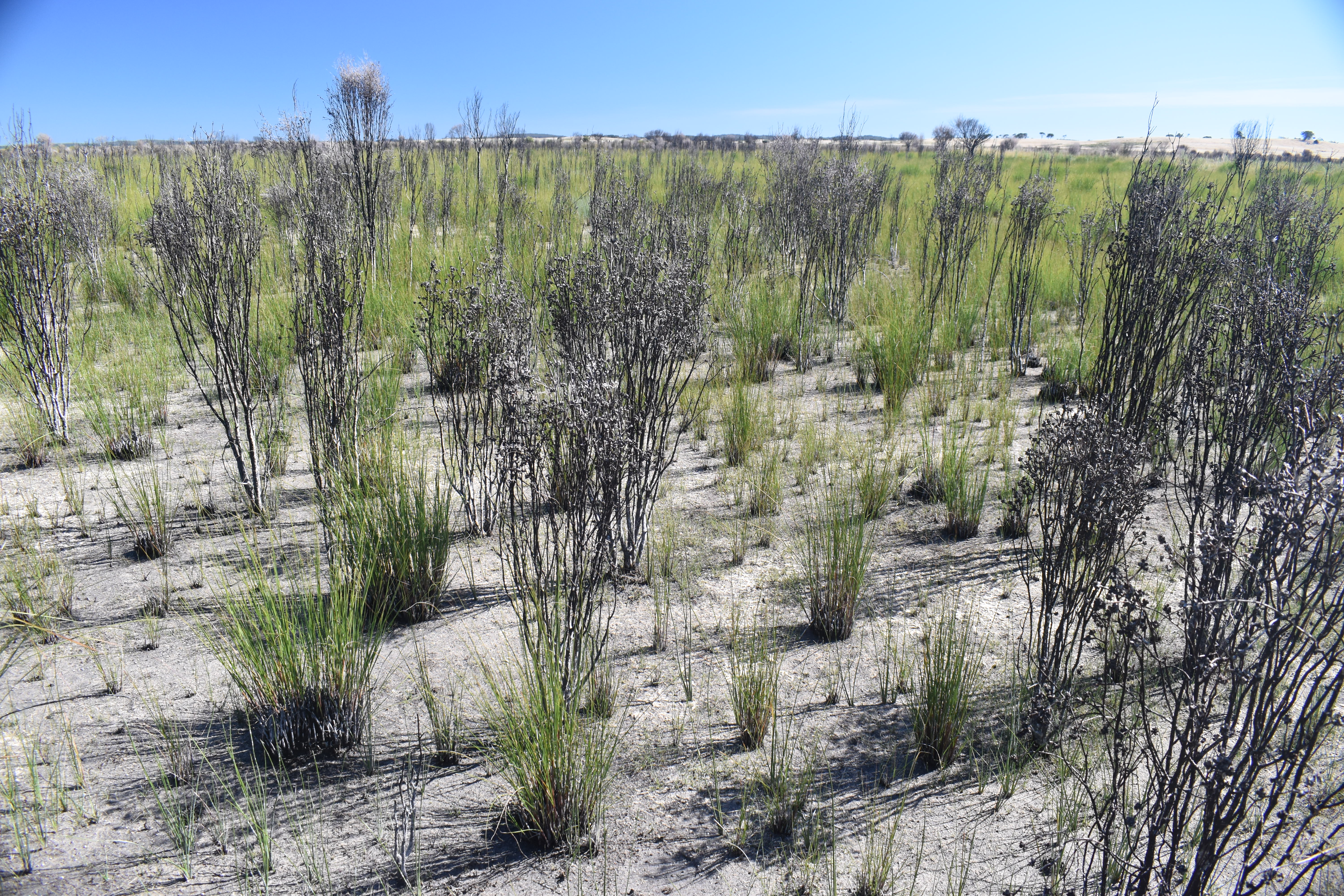
Gahnia filum tussock sedgeland at Lake Hawdon South, December 2018, seven months after fire. Note dead Melaleuca halmaturorum shrubs but resprouting Gahnia tussocks.
The fire appears to have worked well as a tool to control Melaleuca; however, quantitative monitoring over time is required to confirm this. Of ongoing concern is the infrequency of fire and the large areas of the reserve that remain unburned. A fire management plan and a properly resourced prescribed burning program for this important reserve is clearly required (and becoming urgent given the ecological thresholds described above).
To summarise, an appropriate fire regime for Lake Hawdon South would serve the multiple, overlapping objectives of:
- preventing Melaleuca dominance and thereby protecting ecological values,
- reducing the risk of uncontrolled fire and it potential to damage ecological values and neighbouring properties, and
- improving water movement through the reserve and thereby reducing the risk of flooding agricultural land upstream of the wetland.