Latest news on the Rowan Swamp restoration trial during the central Victorian floods
Cropping is a major feature of the flats and floodplains surrounding Rowan Swamp Wildlife Reserve, so this update is provided against the sobering backdrop of knowing that many primary producers are doing it tough at the moment given the period of extended flooding across central and northern Victoria, which is particularly damaging to crops. Unfortunately the same process that makes these floodplains fertile environments for cropping, with soils benefitting from the occasional deposition of silt and nutrients, is also an ever-present risk during wetter phases like the one we are currently experiencing. If you are a farmer impacted by the floods reading this update, we wish you all the best at this challenging time, and hope you can bounce back quickly.
Locals have told us previously that floods along Boosey Creek – a tributary of Broken Creek that joins the Murray River at Barmah National Park – normally arrive and pass through Rowan Swamp (just south of the township of Lake Rowan) within a matter of days, rather than the weeks and months of flooding experienced in some other places. This year we have been able to observe a number of flow events unfold – small, medium and large – and gain an insight into how they are interacting with the restoration trial structure.
This is important information that will help determine the future level of the trial structure and whether it might one day be able to be converted into a more permanent solution to address the erosion issues we have previously discussed are impacting the site. However, even though it will be a while before we can access our water level data loggers (at which time Lachie will be able to give us a much more detailed overview of the various flow events and how water levels have responded) – we can already share a number of interesting insights and observations.
Since the previous Rowan Swamp update, the major rainfall event in mid-October that generated widespread flooding across Victoria also hit Rowan Swamp. When I visited the site on the 19th of October, four or five days later, I didn’t know quite what to expect – or even if the trial structure would still be there!
Fortunately, I arrived to find everything in place and functioning. The level at the structure itself (77 cm at our gauge board) was even back to being at a similar level to what I had seen during previous flows earlier in the season.
For a comparison of what I observed between September and October, see below.
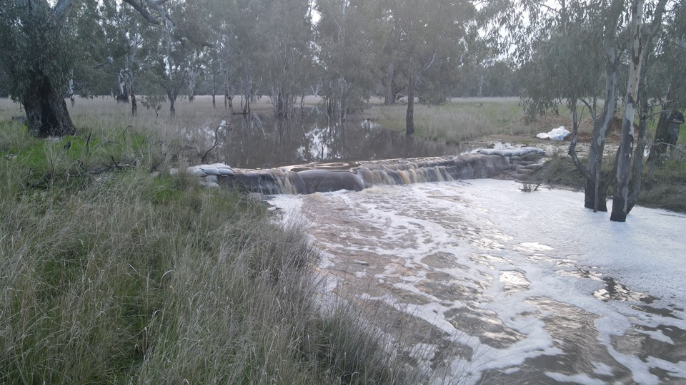

I came across a lot of recently inundated ground, but the peak of the flood had well and truly passed – and passed quickly. But just how high had the water level reached?
While the data loggers will eventually tell us for sure, it was at this moment that the piles of left over sand from the construction of the restoration trial caught my eye. Unbelievably, with the naked eye it appeared as though the high water mark had reached roughly 1 m above the current water level – as shown below.

Fortunately Lachie had installed a time-lapse camera, so we could also check to see if the batteries had lasted long enough to pick up the most recent major flow event. I was actually also a bit concerned that the camera might have gone under water!
When I got back to the car and downloaded the images to my laptop, I could scarcely believe the footage. So at this point, that is enough from me – take a look for yourself!
An incredible surge of water hits in the evening of Thursday the 13th October, and then the peak level is reached the following afternoon on the 14th. It takes a further three days before the structure re-appears, which happened on the 17th, a couple of days before my arrival.
Notice how generally slow moving the water is around the peak level, and how wide the flow path is?
This tells us a few important things like: (a) the main channel of Boosey Creek is overwhelmed very quickly in a major flow, activating the wider floodplain to pass flows, (b) that temporary downstream constrictions (like the channel capacity and possibly the Benalla-Yarrawonga Road in the town of Lake Rowan) cause the water to spread out, back up and velocity to slow, and (c) that there is no difference in the water level above and below the trial structure in a major flow, because the structure is completely submerged.
The good news, if there is a silver lining to emerge from the current floods, is we can already see very clearly from the visual evidence during this event that the trial structure basically becomes irrelevant during a flood given the sheer volume of water involved which rapidly overwhelms the limited capacity of the creek. This was our assumption heading into the trial, but has now been demonstrated in a major flow event.
Finally, it turns out that this is not all…
Several days after my visit on the 19th October, there was a big thunderstorm in the catchment at Thoona which sent another pulse of water down to Rowan Swamp. This time, I managed to visit (on the 26th October, and again on the 29th October) around the peak of this next, albeit smaller, flood event, and could see the behaviour of the creek and floodplain first hand. With the water level at the gauge board now sitting at 1.02 m, the same view of the structure shown at the start of this story, looked like this… yes, I know what you are thinking – what structure!?!
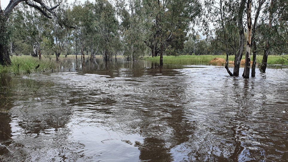
For my recent visit, to even get to this spot, I had to wade through knee to thigh deep water for most of the distance from the reserve entrance, and the flow paths (now multiple) were hundreds of metres wide. The edge of the channel could not be seen.
The change in the appearance of the structure location, as the whole trial has unfolded from images taken during some of my visits, can be seen by clicking through these two pdf documents:
Rowan-Swamp-structrure-view-2-Oct-2022-v2
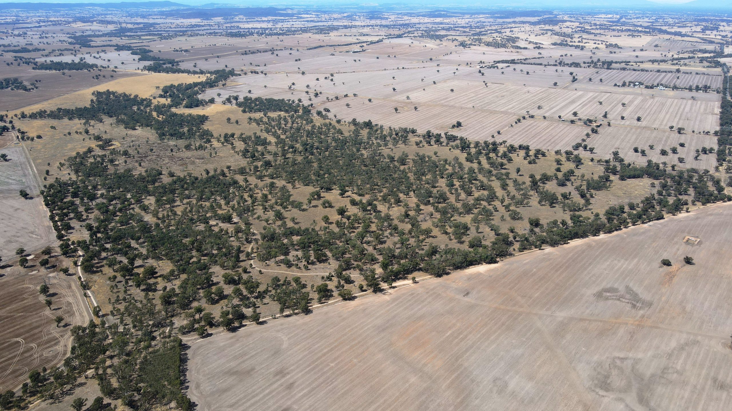
These oblique aerial images help to complete this chapter of the story. Firstly, the swamp when it was dry back in March.
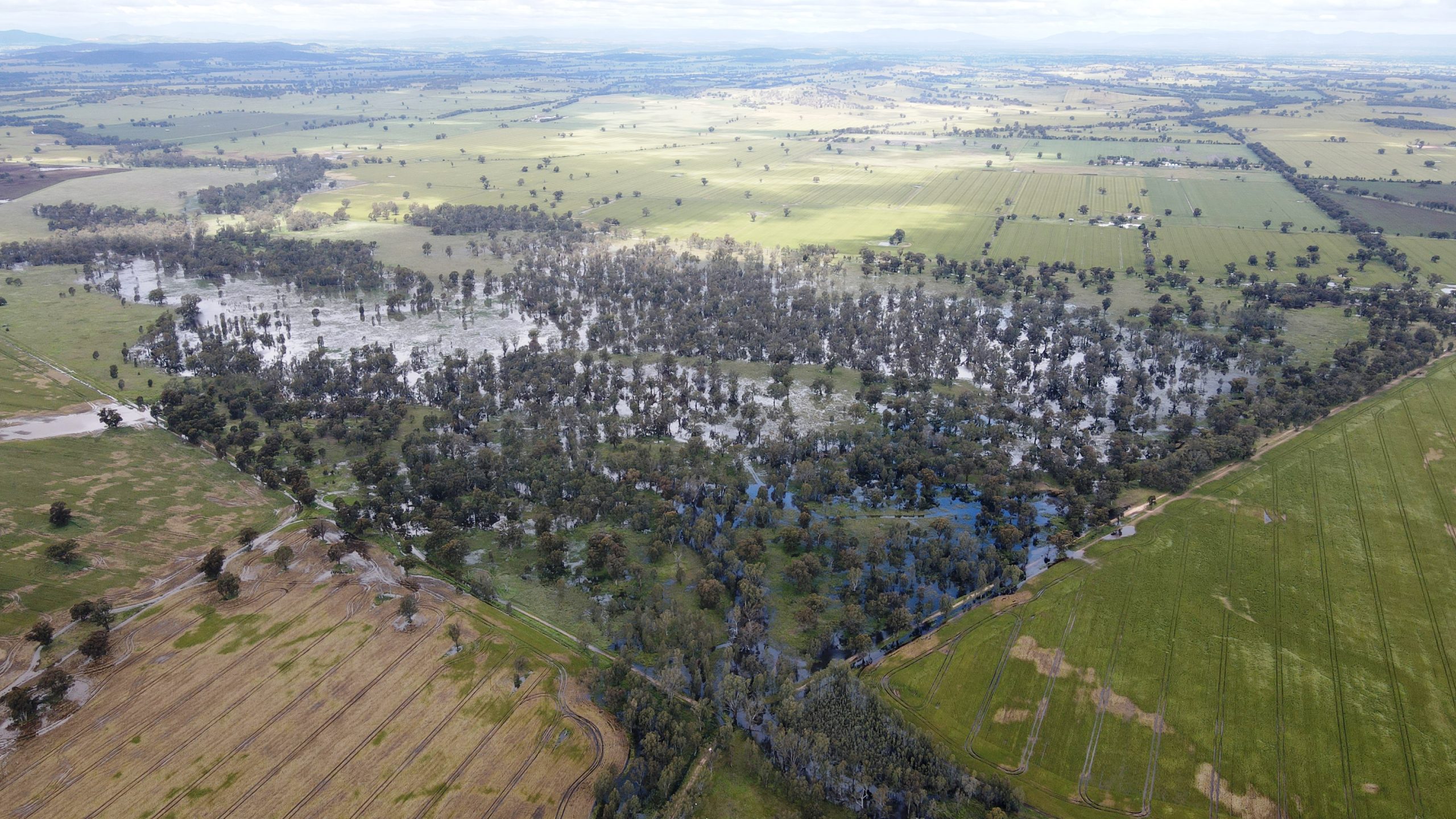
Next up, is Rowan Swamp on 19th October 2022, five days after the peak of the major flood event. The structure location is marked with the arrow.
Finally, here is Rowan Swamp on 29th October 2022, around the peak of the minor follow-up flood event. Note the temporary activation of the floodplain around the creek (bottom of image) as the capacity of the channel downstream is overwhelmed once more. Based on the experience from earlier in October (shown above), this area is not expected to stay under water for long.
And this is a view of the structure from above, showing how flows were already largely contained back within the creek channel by the 19th October, only five days after the peak of the major flood event, and the second page shows the appearance of this area on the 26th October around the peak of the next minor flood event. At this time, the flow path is hundreds of metres wide through the floodplain – giving us some clues as to its likely appearance during the major flood earlier in the month.
Rowan-Swamp-above-v2Eventually, when the rains end and the summer heat arrives, the Rowan Swamp restoration trial will really kick into gear.
Instead of the wetland freely draining to its bed level once inflows cease, by being drawn into the eroded channel, this will be when the trial really begins to have a positive influence on the hydrology and ecology of this important wetland. It will do so by extending the length of time that Rowan Swamp holds water, as a result of the new cease-to-flow level set by the trial structure.
This project is supported by Nature Glenelg Trust, through funding from the Australian Government’s Murray–Darling Healthy Rivers Program and Parks Victoria.