More waterway restoration works completed at Glenshera Swamp, near Mount Compass
Over three wet days in early May, NGT staff (Mark and Ben) got to work with the assistance of an earthworks contractor, backfilling more artificial drains within Stipiturus Conservation Park. This important reserve contains a signification portion of Glenshera Swamp, the largest and most intact example of the critically endangered Fleurieu Peninsula Swamps ecological community. Located 10 km west of Mount Compass, Glenshera has been the focus of hydrological restoration activities by NGT since 2016, with some very encouraging results, as covered in several previous blogs.
Despite the work completed to date, there remain several outstanding hydrological issues to address, a legacy of historical attempts to both drain the swamp and divert flows around it, as well as modify the creekline and floodplain upstream of the swamp. After the most recent works, we can now happily report that some significant further progress towards complete hydrological restoration of Glenshera has been made.
Firstly, to get your bearings, below is the overall picture of Stipiturus Conservation Park.
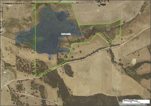
The main focal area for this update is the natural creek line in the eastern portion of the reserve, upstream of Glenshera Swamp, noting that flows occur in this area from east to west (right to left).

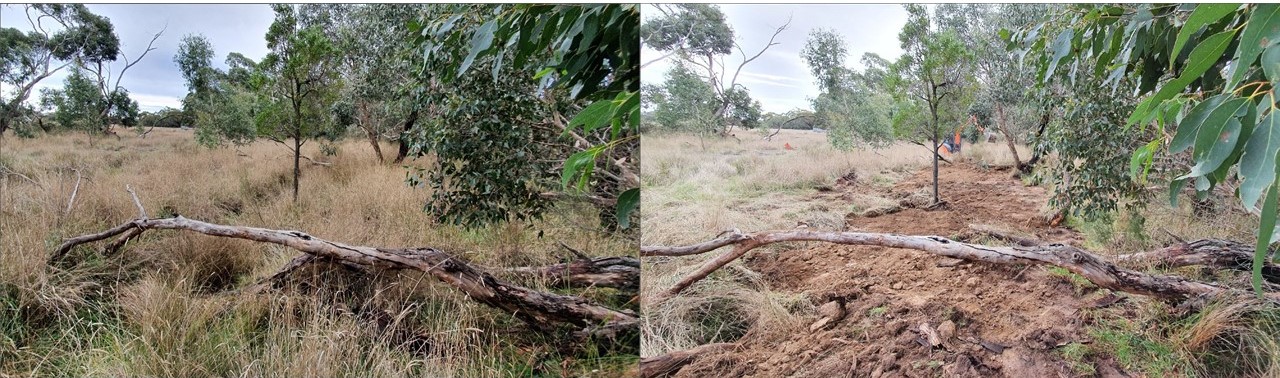
The first maps show how the creek line (blue) originally formed out of an area of broad sheet flows off a wet flat, eventually creating a shallow meandering stream. This waterway delivered water to the swamp downstream via slow, low energy flows in a shallow vegetated channel, wetting areas of peripheral floodplain habitat along the way. For a visual guide, here is a view of a (now dry) remnant section of the original creek, where it meanders close to the natural embankment that borders the floodplain on the northern side…

The next view of the same area shows how artificial drainage has completely interfered with the creek and floodplain. An artificial channel was constructed in the 1940s along the entire length of the watercourse, whether there was a channel there or not. In some places the natural channel itself was deepened, in others it was completely cut off or bisected, while upstream, where there was no natural channel, a drain was also cut through the sedgy floodplain area.

Beyond the obvious eco-hydrological impacts of starving the original creekline of flows and drawing groundwater out of surrounding soils, the reason this is such a big deal is all about energy. Concentrating flows into a single, deeper channel, and increasing its velocity, creates the potential for erosion…

The image above is in stark contrast to the natural creek a few metres away. Drain construction breached the natural topsoil, exposing clay sub-soils that are more prone to erosion and difficult to stabilise. So over time, the drain has eroded and deepened, further exacerbating the issues of channelisation and flow velocity. Basically we are caught in what we call a ‘negative feedback loop’ – where these detrimental factors reinforce themselves and push the system further and further away from its original state. Over time, a large amount of sediment has been washed downstream and the drain is now up to two metres deep in some sections – you definitely don’t want to fall in!
So, you might ask, what can we do about all this?
This map gives the overview of our works so far in the upper section…

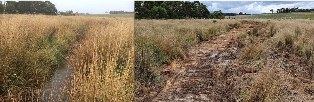
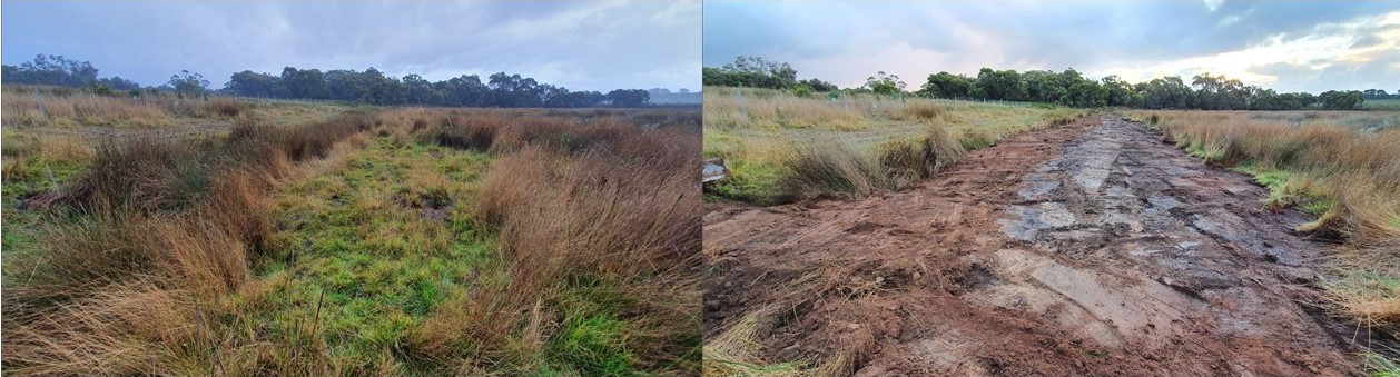
The green dashed line shows where we were able to completely backfill the drain, using an excavator to carefully re-use the available spoil material that was still sitting next to the drain since construction. These spoil mounds are still easy to identify – they are elevated and generally covered in weedy grasses. Between numbers 1 and 2 the fall is slight (which is why there was no natural defined flowpath in this section) and the drain hadn’t badly eroded, so we had enough spoil available to do the job. Here is the before and after view…
From number 2 west, downstream to 3, the job became increasingly complex, as the drain became deeper and cut across the natural channel at multiple locations. Again, the green dashed line is where the drain has been backfilled, while the red dashed line shows where there was insufficient spoil or poor access, meaning these sections of the drain have been left open for the time being. The blue line indicates where we now hope the works will result in reactivation of a section of the original meandering stream, which includes the section in the photo shared earlier in this story.
The red dot at 3 is the location of a new spillway structure we built in the drain to create an upstream pool, so that flows dropping back into the drain from the restored flow path do not cause erosion. Ultimately if and when the creek is fully restored one day, this structure will become redundant.
Finally, downstream of number 3, the yellow line is where the original stream is still left high and dry – a job for another day! In these areas access to the drain is a little more challenging due to the presence of fallen vegetation, and the drain has so deeply eroded since its original excavation that to completely backfill it would require more material than remains in the adjoining spoil mounds alone.
As shown below, once we continue downstream of Barb’s Track culvert, we reach the section of the artificial drain (shown in red) that originally caused all surface inflows to bypass the main part of the swamp. This is where sandbag weirs constructed by NGT and volunteers in autumn 2017 (yellow bars) partially restored the natural meandering flow path of this watercourse and redirected flows back into Glenshera Swamp, as shown by the blue line.
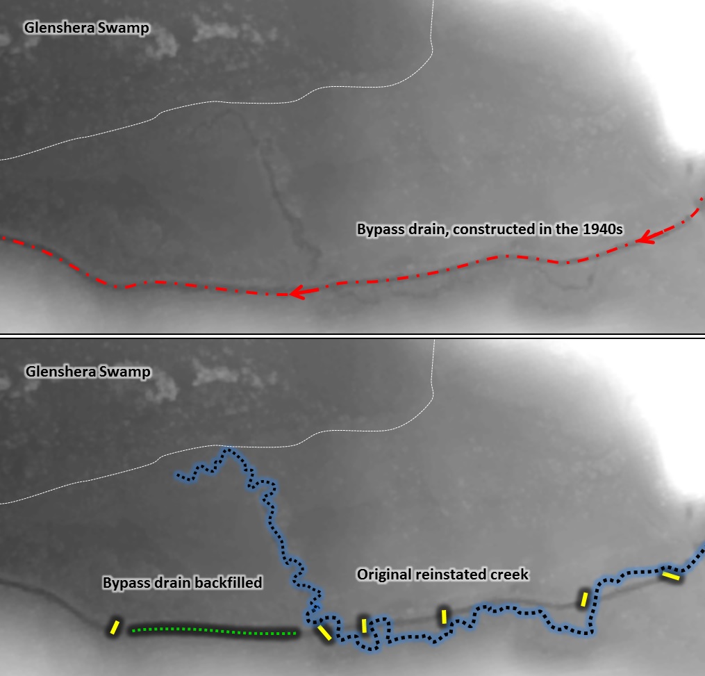
In autumn 2020, we’ve complemented these previous works by back-filling a short length of active drain that remained in place, downstream of the final diversion point into the swamp and where access was straightforward. This is shown in the green dashed line above, and also in the before and after image below.
In summary, we anticipate these latest works will:
- lift surface inflows up out of the artificial drain and disperse shallow water across a broader area, particularly in the flat, swampy eastern area of the reserve;
- slow flow velocities, hold water for longer and force water through more vegetation, which will improve water quality entering the main swamp downstream;
- encourage the natural regeneration of native wetland vegetation across a larger area, particularly in the east of the reserve;
- reactivate a very pretty section of the natural watercourse upstream of Glenshera, with likely benefits for stream adapted flora and fauna;
- ensure that from now on all surface flows entering Stipiturus CP will be redirected back into Glenshera Swamp via the original flowpath, helping to protect and maintain this highly significant wetland, in perpetuity.
Hopefully there will be more works to follow in the future, but for now we are looking forward to monitoring recovery of these areas over the months and years ahead – so stay tuned!
This work is supported by the Adelaide and Mount Lofty Ranges NRM Board, through funding from the Natural Resources Management Levy and the Australian Government’s National Landcare Program.