What happens when water levels change or the ground sinks beneath our feet? – Let’s talk about subsidence in drained peatlands and just how much wetland plants move around
Over the years at NGT we’ve worked on wetland restoration investigations and implemented projects at wide range of wetland types. If you have been following these stories for some time, you will have seen how valuable digital elevation data (a Digital Elevation Model or DEM, based on LiDAR information) is at the planning stage of our projects.
Below is an example of how we can visually illustrate the impact of drainage on a modified wetland to a landholder, as well as explain what the effect of hydrological restoration will be – in this case showing the impact of increasing water levels in 10 cm increments.
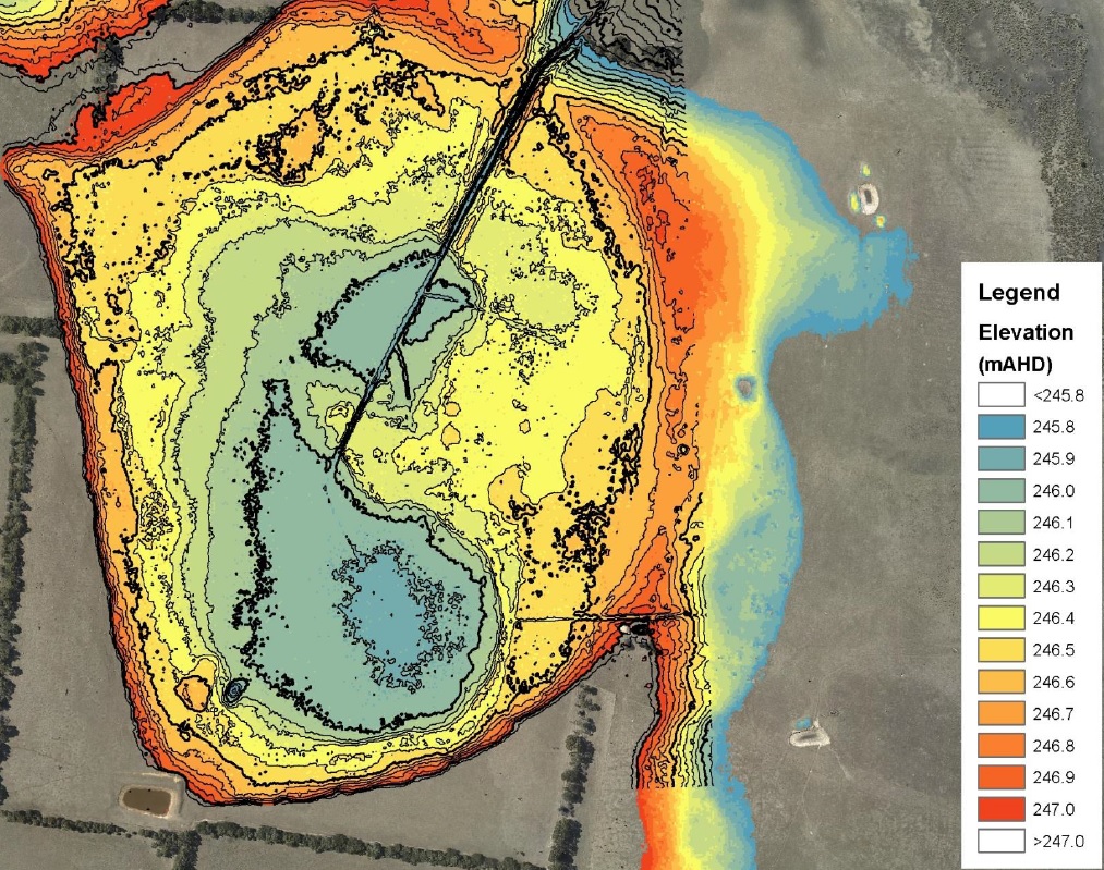
By looking at the DEM and identifying the original sill (or natural full supply level), we can infer original wetland depth, extent of inundation, its likely water regime and even gain some clues that help us determine the likely original distribution of wetland vegetation communities across the wetland before the outlet sill level was modified by artificial drainage. In the example above, the natural sill level was approximately 246.5 metres above sea level, and the bed of the wetland is around 245.8 – meaning that the deepest part of this wetland (blue areas) would originally have held around 70 cm of water before spilling out of the wetland basin to the north. However, the artificial drain you can see here all but eliminated this wetland, with the channel being cut all the way to the deepest area shown.
It may come a surprise to learn that, because so much wetland vegetation is responsive to seasonal conditions and is not especially woody or perennial, most of the grassy, sedgey or aquatic species we find persisting in modified wetlands like this actually make very poor (i.e. unreliable) indicators of long-term conditions for wetland restoration planning purposes. With the exception of woody wetland plants that live for a very long time (think River Red Gums), just because you find something growing in one location today, does not mean it always grew there, or that it will even be there again next year. This is why long-lived species make excellent long-term indicators, but short-lived species in wetlands definitely do not!
For an interesting example of what the grand old Red Gums taught us during our restoration planning work at Walker Swamp, please refer to the maps and description below.
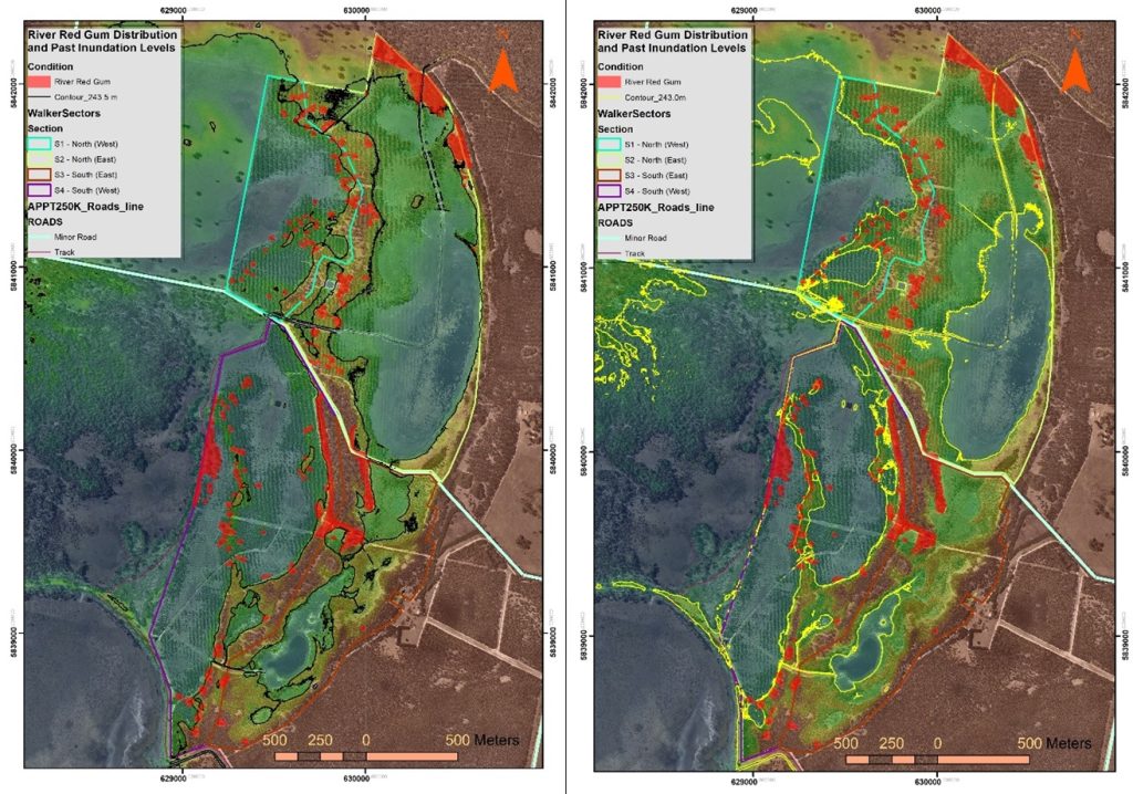
By reviewing the distribution and elevation of the old Red Gums across Walker Swamp, many of which are hundreds of years old and grow at or above high water mark, and closely assessing the natural surface prior to artificial drainage, we were able to determine that Walker Swamp proper had a natural sill level 50 cm higher than the level where Red Gums are found growing on the western floodplains of the very same property, simply separated by a lunette bank. This confirmed for us that Walker Swamp has always had a hydrological regime that has operated somewhat independently and at a higher level than the adjacent floodplain. As you can imagine, this was absolutely critical knowledge for us to integrate into our hydrological restoration plans before the work began…

Now this all might seem complicated enough, but what do you do when the level of the ground itself in a wetland can dramatically change over time?
The wetlands shown above are mostly seasonal systems that can fully dry out during extended dry periods, and are underlain by mineral soils. This means that they are not prone to dramatic changes in the elevation of the wetland soil surface over the periods of time relevant to our work.
But we have also worked over the years at a number of wetlands underlain by peat sediment, and restoration planning there is a different story!
What is so different about peat wetlands?
Peat is an organic sediment that forms when dead wetland vegetation accumulates over time in the bed of a permanent wetland, due constant saturation/inundation. This is an anaerobic biological and hydrological process, driven by rainfall and/or groundwater, which prevents full decomposition of this organic material.
But when peat sediments dry out due to a falling water-table or are deliberately drained and developed for conversion to agricultural land use, subsidence – the subsequent lowering of the ground surface within the former wetland – is an absolutely inevitable and unavoidable consequence of that process, as shown in the below images. At some wetlands, this can result in the physical surface elevation ultimately changing (falling) by metres.
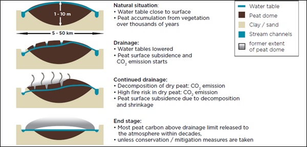
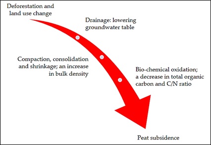
Physically, peat subsidence is initially driven by the massive loss of volume caused simply by artificial drainage removing water from the peat, which is generally constituted of 90% water / 10% carbon, prior to drainage. After drainage, the organic material that is left behind physically ‘slumps’ or compresses very rapidly (i.e. its bulk density increases as it collapses/shrinks under its own weight) because so much of the original volume was taken up by water. This physical compaction process can be further hastened by livestock trampling the now dehydrated peat. With this dramatic change in physical properties and management, the original peat-forming vegetation is either deliberately replaced (via clearance) and sown to pastures or other introduced species, or will otherwise transition to native species more tolerant of drier conditions.
After the physical changes have taken place, chemical processes then begin to kick in, as the organic material that is left behind after drainage, has suddenly flipped from an anaerobic to aerobic state. Just as the saturated, anaerobic conditions were the key ingredient in peat accumulation (i.e. preventing decomposition), with the dehydrated organic material now interacting with oxygen and a new aerobic soil microbiome, the reverse becomes instantly true. Oxidation of peat (off-gassing to the atmosphere as CO2) then becomes a key driver of peat loss over subsequent years and decades, as the physical and bio-chemical processes feed off each other. It also makes the peat more prone to burning in fires, which can rapidly accelerate the subsidence process. The speed and magnitude of subsidence is directly related to the depth and proximity of artificial drainage, because any peat that remains saturated will resist these changes.
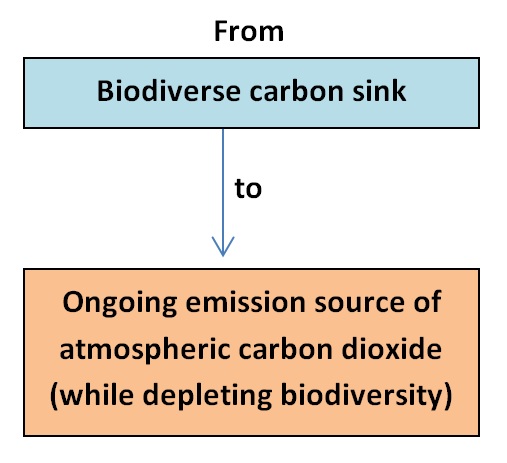
The net effect of all these changes on a peatland is that the system goes from being in a:
• positive feedback loop – where carbon builds up (generally measured in mm per year) and sees the peatland grow in volume over time, as the local water-table rises with the accumulating organic material.
To a:
• negative feedback loop – where dehydrated peat is not capable of growing peat-forming plants, nor providing peat forming conditions any longer, which triggers the physical and chemical process of peat subsidence (generally measured in cm per year).
Importantly however, the rate of peat subsidence is not uniform over time, as the New Zealand data shown below illustrates.
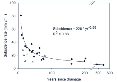
This is because there is an initial, very rapid change in bulk density due to dewatering and compaction, gradually replaced by oxidation being the main ongoing but slower source of subsidence. However, if artificial drains are not maintained or deepened, or in places where that is not possible on an ongoing basis (e.g. near sea level), then this can also impact the rate of subsidence, as the surface depth to water-table decreases again over time.
Indeed, there are many instances where drained peatlands, after subsiding, gradually start to regain some of their prior values as the upper peat profile becomes increasingly wet, or even starts to inundate again. We have seen this occur at many Fleurieu Peninsula Swamps, where people often mistake these emerging values as being “remnant”, when they are simply a form of natural transition and regeneration at sites where the original values had been physically lost for a time (but may have persisted in low points and drains, or as a dormant seed bank) and later regenerated or recolonised in response to subsidence-induced rewetting of the peat.
At a place like Eight Mile Creek Swamp (near Port MacDonnell, in the South East of SA), one of the largest original alkaline peat fen wetlands in southern Australia prior to drainage, subsidence in the decade immediately after it was drained, cleared and sown to pasture was so severe that the land had to be re-drained for it to remain viable for the settlers who took up land there. This is the more common scenario in many peatlands, where drains simply get deepened over time to keep up with subsidence rates – but of course this only works for as long as the elevation gradient (i.e. the downstream water level) makes it physically possible to do so.
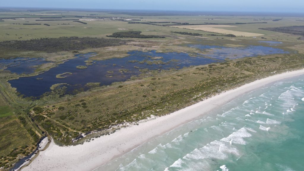
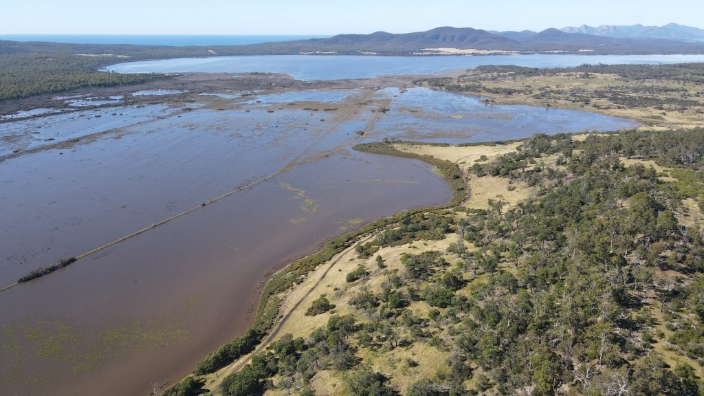
At the Apsley Marshes Ramsar site, adjacent to Moulting Lagoon in Tasmania, the drains that were constructed to dewater a large area of fresh, groundwater fed peatland more than 150 years ago, now funnel seawater under high tides back into the sinking peatland – which is causing salinisation and vegetation change in the area shown below (note that this image is during a flood in March 2021, so this is not seawater in this image, but it does show proximity to sea level, with Moulting Lagoon in the background).
For this reason, subsidence means that most coastal peatlands that have been drained and developed near sea-level only have a finite life in their artificially drained state, with the impact of sea level rise only accelerating progress towards to that outcome.
Across the world, peat covers just 3% of the land’s surface, but stores 42% of the Earth’s soil carbon, and peat degradation as a result of artificial drainage is estimated to be responsible for 6% of global carbon emissions. This is a massive issue that fortunately, we can do something about.
Improving the management of our peatlands in Australia is a clear priority for carbon, water and biodiversity outcomes – noting that wetland hydrological restoration is the key tool we have available to us for avoiding future ongoing peat subsidence and oxidation of this carbon to the atmosphere. In short, we can lock that carbon back up by re-inundating peatlands – and deliver a rapid biodiversity response at the same time.
If you are interested to restore the hydrology of your peat wetland, then feel free to send us an email and we’ll do what we can to help:
PS – Some of the wetlands we have worked at over the years, or continue to work at, where peatlands occur include:
- Apsley Marshes (Tas);
- Piccaninnie Ponds and Pick Swamp (SA);
- Long Swamp (Vic);
- Hutt Bay Wetlands (SA);
- Mt Burr Swamp (SA);
- Glenshera Swamp (SA); and
- Square Waterhole Swamp (SA).