Sharing the “blue-print” for restoring Fleurieu Peninsula swamps
Now that many of us are temporarily stuck at home again, it feels to me like a lifetime ago – but just a few weeks back, I managed to check in on one of my favourite places on the Fleurieu Peninsula – Glenshera Swamp. This wonderful (and largest) example of the critically endangered swamps that occur on the Fleurieu, is a place that will be familiar to many long-term readers of the NGT newsletter, as we’ve tracked its restoration progress over the years.
On my most recent visit, I started by checking out how the areas of back-filled drain in Stipiturus Conservation Park are looking. As you will see in the example below – the short answer is “great”!
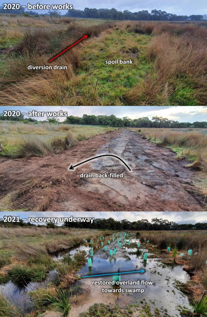
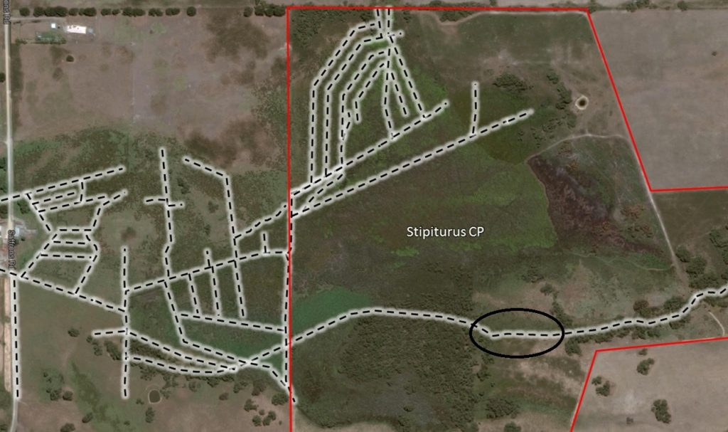
The back-filled drain is not only resulting in the redirection of flows out of the drain and back into the main swamp, but it will also allow significant expansion of swamp back into its former footprint through re-saturation of the soil profile across the intervening strip of land that was cleared in the 1940s. To help get your bearings, the location of this back-filled section of the diversion drain, in the context of all the former agricultural drains at Glenshera Swamp (yes, there are/were a lot!), is circled on this map:
In summary, the trajectory of recovery that we were aiming to initiate with these works last year is well and truly underway, ably assisted by active revegetation works being completed by the Hills and Fleurieu Landscape Board.
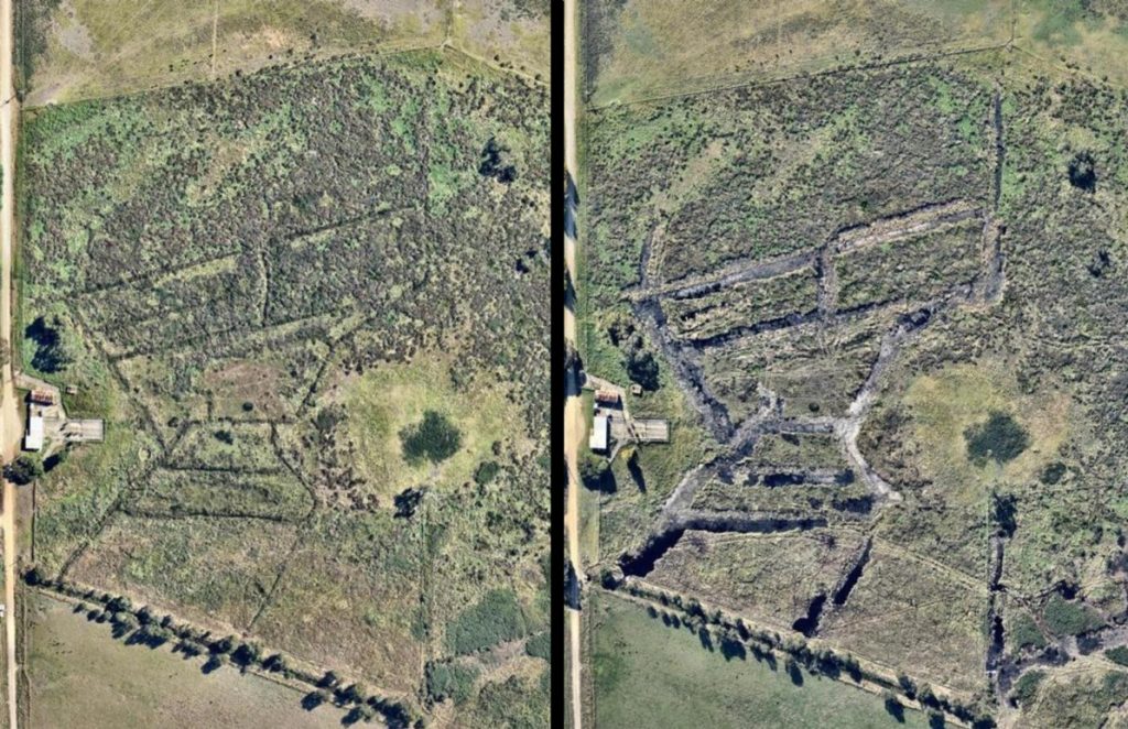
After giving these works a big tick, I also ducked in next door (with the consent of the neighbour – thanks Chris!), to check on the private portion of Glenshera Swamp. To recap, it has now been four years since we back-filled the network of drains through this area of previously quite degraded peatland, as shown. As you can see in the ‘after’ image below, the black areas of pooling water show that doesn’t take long for groundwater-fed sites to re-saturate, literally from the ground up!
So here we are, now four years later, and every time I see this place all I can say to myself is “Wow!”
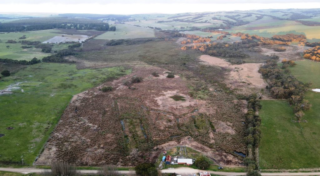
This substantial peatland area is a prime example of hydrological restoration underpinning both natural regeneration and targeted revegetation.
Natural Regeneration
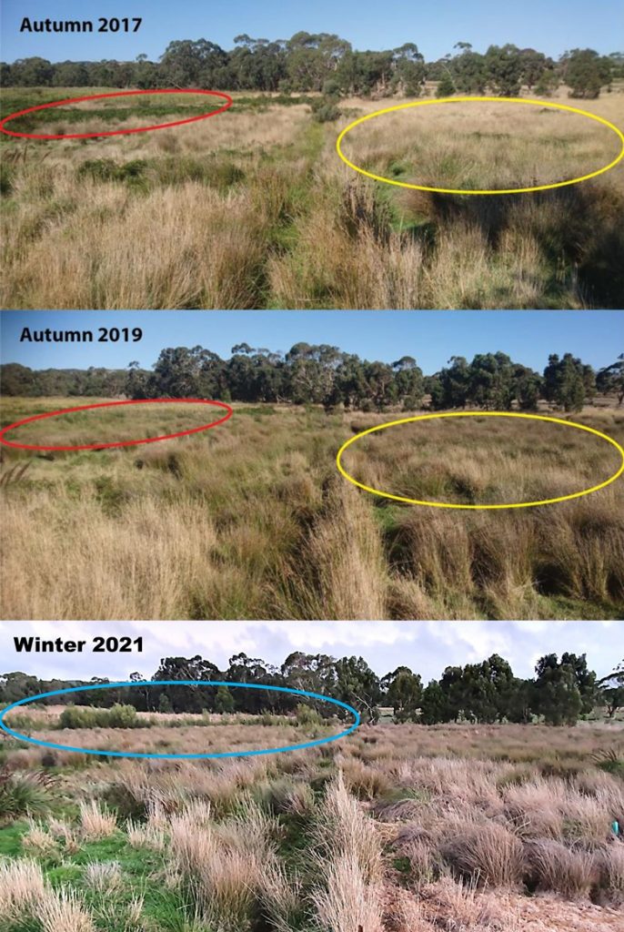
The photo below shows how natural vegetation transitions are underway since the peat was re-saturated. The red and yellow circles respectively show the rapid displacement of bracken and pasture grasses by wetland plants, while the blue circle shows the natural emergence of tea-tree and other wetland shrubs in and around the disturbance footprint where the main artificial drain was backfilled. Luckily in this area there was already a wide range of remnant wetland plants scattered about to help trigger this natural process of recovery.
Of note, nothing in this image had to be planted – these transitions are all taking place by simply fixing the hydrology of the area, and nature is doing the rest.
Active revegetation
A little further west and active revegetation is being used to speed up the process of recovery because, due to past management, this area retains less diverse remnant native vegetation. If you enlarge the image below, you will see some of the guards around many thousands of tea-tree and other seedlings that have been planted through this newly re-saturated slope over the past 2 years to ‘fast-forward’ the recovery process. This fantastic revegetation work is being managed and funded by the Hills and Fleurieu Landscape Board.

In looking at this image it is also worth bearing in mind that – because of the slope – this is a type of recovering peat swamp habitat where the ground typically saturates rather than inundates. Perhaps a good way to visualise this, is to think of the peat being like a sloped sponge (rather than a basin) that remains fully saturated but is also always laterally leaking water downslope.
In fact, because of the gradient up the slope, we couldn’t just block the drain in one or two places – this simply wouldn’t have worked. To effectively re-saturate the peat, the drains had to be entirely packed (filled in with the adjacent spoil heaps from when the drains were dug) and the natural surface knitted back together again. This short term re-disturbance (of the original disturbance footprint from when the drains were dug) is absolutely necessary to deliver long-term and self-sustaining results. Genuine restoration simply cannot occur without it.
Needless to say, once we did that back in 2017, the groundwater rapidly rose all the way back to the surface and this peat slope has been constantly saturated again and seeping water ever since. Of course, it would have been like this for millennia prior to drainage, because these are the very conditions required to form peat sediment in the first place. A very exciting thing to witness!
The “blue-print” for Fleurieu Swamp recovery
The most pleasing thing about the work that has been undertaken at Glenshera Swamp over the past few years, is that the restoration and recovery process at this site during this time has occurred in the right order.
I can hear you possibly asking “you mean there is a wrong order”?
The answer is a most definite yes!
Think of it like this: a previous owner dug the drains (see just how many earlier in this story) to deliberately dry the ground out, in an attempt to grow an entirely different suite of plants (i.e. pasture species intolerant of saturation) with different physical requirements to what was growing there naturally. So at any wetland altered by drainage, if we rush out and start revegetation work before fixing the water regime first, we have two major issues to consider:
- We risk planting the wrong plants, in the wrong places – because site conditions (i.e. the altered water regime we are inheriting) is literally still the same as that which caused the degradation of the wetland in the first place. The existing distribution of native species is not always a reliable guide either, because shorter-lived wetland plants are very capable of moving over time – up and down slope in response to changing conditions. Hence under this scenario, you could accidentally spend lots of time and money planting dry-land species in places that eventually will go under water when the water regime is fixed.
- Even if the right plants are put in the right places (in readiness for a future restored water regime), they may not do as well as they should or indeed not survive at all, because the underlying conditions will be too dry for them.
I have observed over the years that people often get confused with this, especially on land with a history of disturbance prior to reservation, because swamps have a habit of slowly recovering some of their former natural values – especially if the artificial drains were either not entirely effective or were not maintained – allowing the site to get a little bit damper again over time. In the case of Glenshera Swamp, although it retained incredibly important residual biodiversity values when a portion of it was formally protected in Stipiturus Conservation Park – we also have to remember that these values were persisting despite everything that had been done to the site during the preceding 70 years, when it was not managed for conservation.
In short, it was a highly modified site that really needed our help to capitalise on those residual values that had held on, and isn’t it great to see the site now improving over time, both inside and outside the reserve boundary? The lesson here is that sometimes conserving a site means actively intervening to undo past damage.
So, the “blue-print” is this: if you want to restore or recover any wetland habitat and plan to undertake active revegetation works, remember to address the most important underlying factor first – before all else – and that is hydrology. Once you fix the water regime, not only can the rest then follow with confidence, but you’ll also get much better and lasting results!
If you are interested to restore the hydrology of your wetland on the Fleurieu Peninsula (or anywhere for that matter), then feel free to send us an email and we’ll do what we can to help:
The works in this update are supported by:
