After the floods … the return to Minyumai in northern NSW
Back in March 2022, we introduced readers to Minyumai Indigenous Protected Area (IPA) in coastal northern New South Wales. Owned and managed by Bundjalung traditional custodians through the Minyumai Land Holding Aboriginal Corporation (MLHAC), Minyumai IPA is a 2,163 hectare property of forests and wetlands adjoining Bundjalung National Park about six kilometres south-west of Evans Head. The property has a history of disturbance including logging, clearance and drainage of some areas to establish pasture for cattle, although much of the property retains intact native vegetation. In the late 1960s/early 1970s, three separate areas of Minyumai, covering a total area of 340 ha, were cleared and drained. Since then, native forest, including swamp forest dominated by paperbark (Melaleuca quinquenervia) and/or swamp oak (Casuarina glauca), albeit with a weed dominated understorey, has re-established within much of this area, through both natural regeneration and active revegetation.
However, one area has been stubbornly difficult to restore and remains dominated by the introduced pasture grass Setaria sphacelata, with few trees. This area, now known as Setaria Flat, features a large, artificial channel that prevents surface water from spreading and dispersing naturally across the land surface. The channel was originally excavated as a drain that we estimate (by observing the remnant spoil mound) to have been approximately 1 m deep by 2-4 m wide, but has subsequently eroded significantly, both vertically and laterally. This eroded drain is now 2-4 m deep by up to 10-15 m wide. A key objective at Minyumai is to see if we can develop options to mitigate the effect of this channel and restore the natural, shallow and dispersed flowpath for surface water through Setaria Flat, which will likely disadvantage the introduced pasture grass and favour native floodplain flora and fauna.
On our first trip to Minyumai in February, we installed water level loggers in and around the channel through Setaria Flat (see map below). As it happens, two of the most significant rainfall events in recorded history for the area occurred shortly afterwards, one in late February and the second in late March. These events caused the record breaking, catastrophic floods in the nearby Richmond River catchment, which destroyed countless homes and disrupted the lives of many people, including several MLHAC Rangers, with significant ongoing impacts. Although Minyumai is outside the Richmond River catchment, with a much smaller local catchment running to the coast via Jerusalem Creek within Bundjalung National Park, Minyumai was affected by the rains, with damage to the main access track – rendering the reserve inaccessible for several months. In mid-July, I was finally able to return to Minyumai and was pleasantly surprised to find the five loggers still located right where we had installed them prior to the floods. We have now downloaded the data, which provides a very important record of an extreme event that will help greatly with the design of any structures and/or works required to restore the hydrology of Setaria Flat.
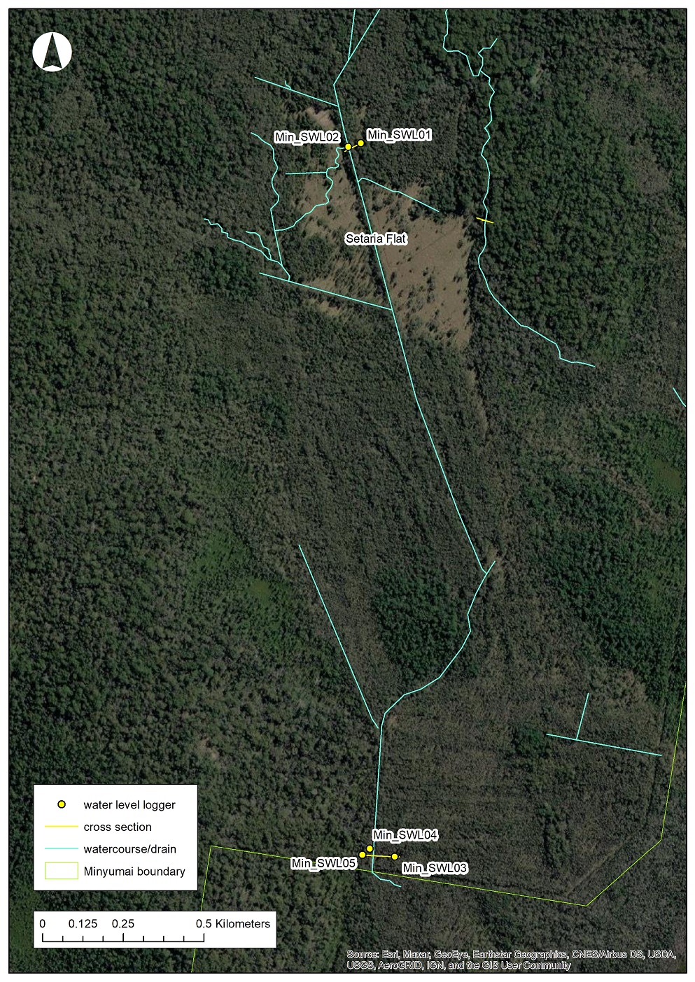
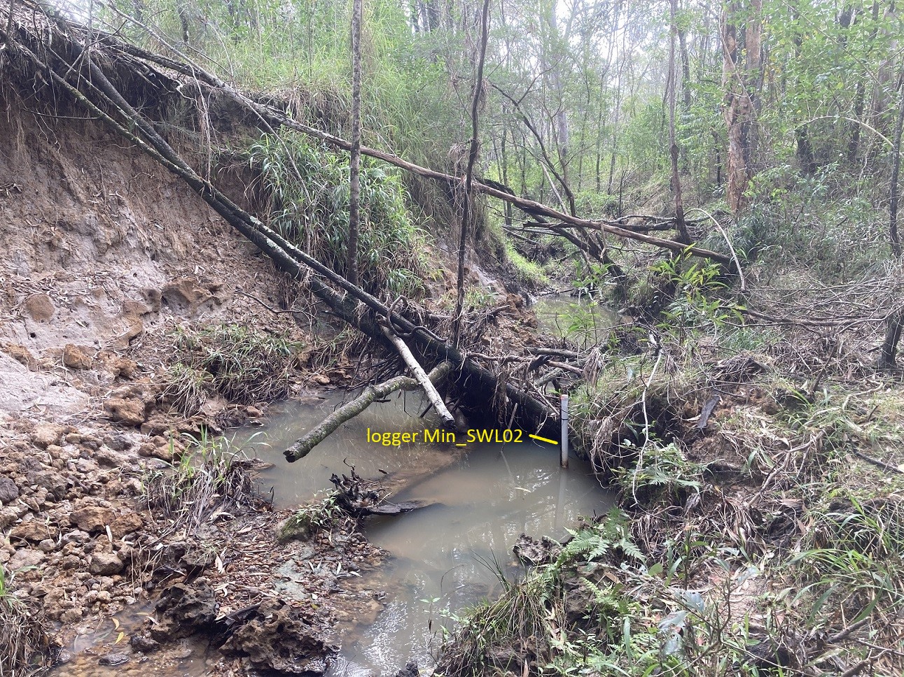
As the map shows, logger “Min_SWL02” is located within the main drain towards the upstream (northern) end of Setaria Flat. The drain in this location is about 3 m deep by 12 m wide and shows evidence of ongoing erosion, with steep, bare sides and recently fallen trees (see below). Flows within this drain are typically a slow trickle connecting a chain of shallow pools, as shown in the photograph. Our logger measures the water level once per hour.
The data for the period 10th February to 20th September 2022 are shown in the chart below. The two high flow events can be seen, the first peaking at 2.57 m at 4.00 pm on 27th February, the second peaking at 2.73 m at 8.00 pm on the 29th of March. Several other, smaller flow pulses can also be seen in the first half of the year. After early June flows decline, with just a few minor events.
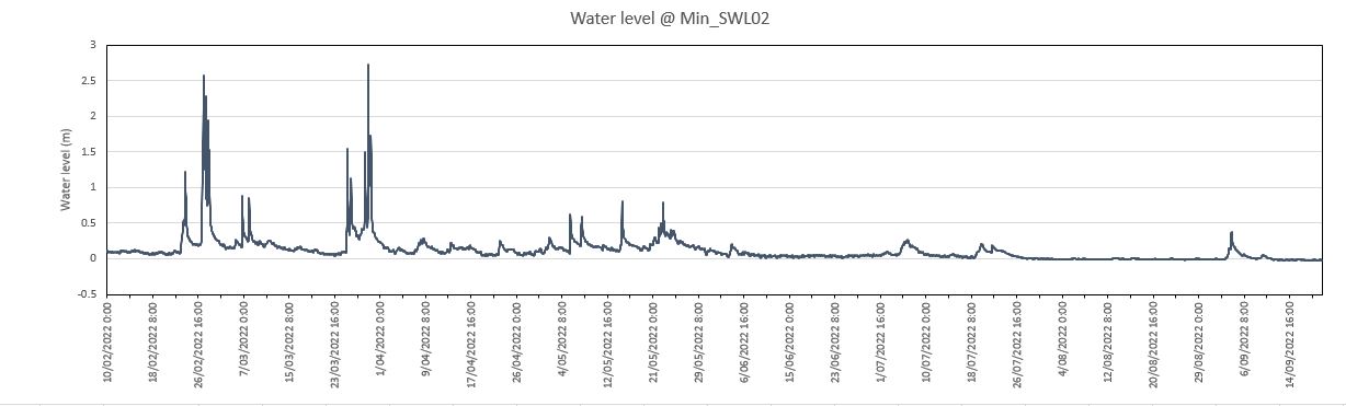
The cross-section below shows the shape of the drain and the peak water level of 2.73 m on the 29th of March. Even this very high flow was entirely contained within the drain, showing how effectively the drain is preventing the natural dispersal of water across the surrounding floodplain. This information from such an extreme event will be very useful as, in collaboration with the MLHAC and our other project partners the Mulloon Institute and Give Soil a Chance, we look to develop options for rendering this drain ineffective and restoring surface flows to Setaria Flat.

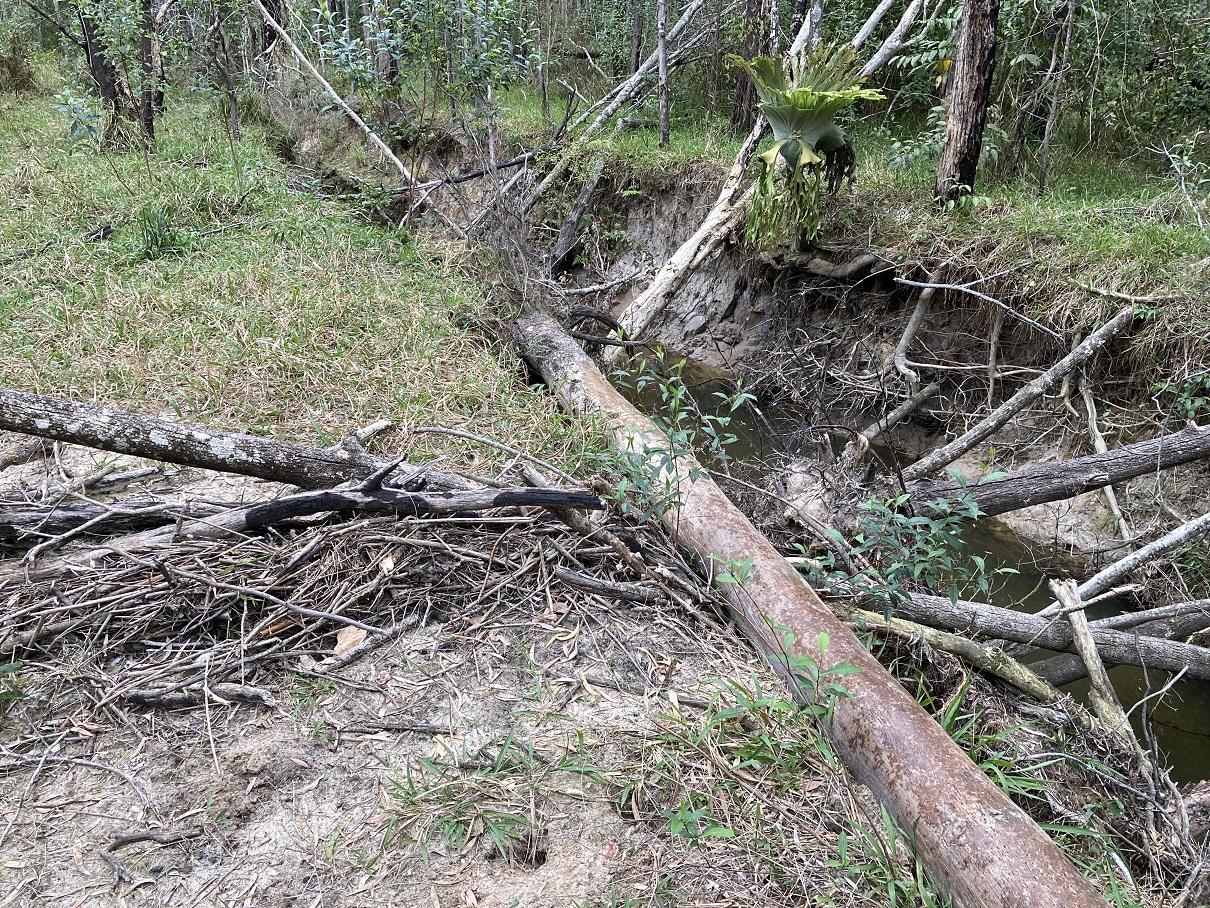
Our trip to Minyumai in September also revealed damage done during the high flows in February and March. Along some sections of the main drain there has been considerable lateral erosion, with many trees that were intact in February now collapsed into the drain (see below).
Further downstream, near where the drain ends blindly into Bundjalung National Park, the recent floods have deposited a considerable amount of sand onto the surrounding floodplain (see below). It is likely that during the 50 years since this drain was first excavated large volumes of sediment have been deposited into the wetlands of Bundalung National Park. Putting an end to this process would be a valuable secondary outcome of hydrological restoration at Minyumai.

Finally, and for comparison, natural undisturbed waterway habitats on the property have a very different appearance to the deeply eroded artificial drainage channels, as shown below. Such areas provide a very useful guide and reference for our work.

This project is supported by the Banjanlang Clan who are the Traditional Owners and custodians of the Minyumai IPA and the NSW Environmental Trust.