Forensic fieldwork: Investigating the vegetation of Mt Vandyke
Where do you start when you want to restore a cleared patch of agricultural land back into a functioning, healthy, natural ecosystem, and it’s not immediately obvious what used to grow there? It’s a common problem facing us when restoring habitat in fragmented landscapes, and it can require a forensic approach to arrive at an answer.
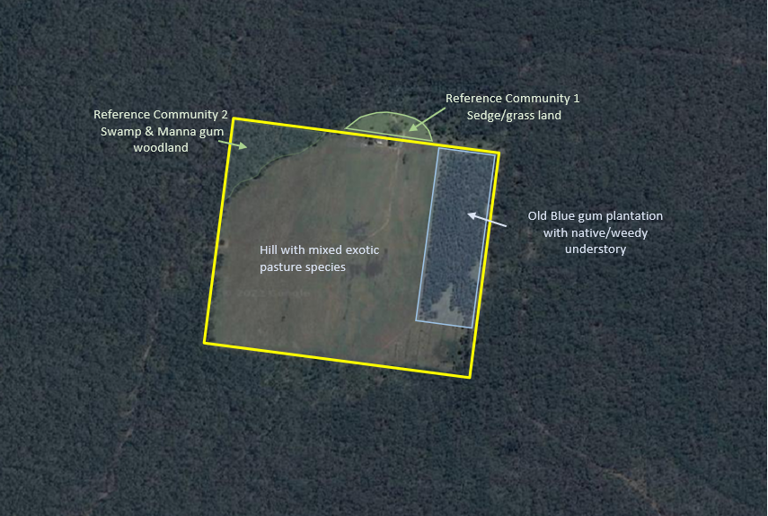
Our Mt Vandyke reserve has a fairly unique history; it’s a volcanic peak, historically cleared for grazing and then developed for plantation forestry. Now it’s on its way to becoming NGT’s first predator-proof small mammal reintroduction site. We are committed to restoring the native vegetation of the site, to provide a healthy and diverse habitat for the eventual release of threatened fauna. So how do we decide what to put back? As the aerial image below shows, there is little native vegetation remaining on the hill itself.
Like all investigators, restoration ecologists start with the evidence:
- Is there any native vegetation at the site, particularly long-lived trees or shrubs, that might have been there before it was cleared?
- Are there remnants nearby that are similar, and is it likely they occurred here?
- What do the soil types, land-form, slope, and hydrological conditions tell us about the likely types of vegetation that once grew here?
At Mt Vandyke there are some important clues that point us in the right direction. Looking at published information, including anecdotal and historical evidence, we believe that Mt Vandyke was once covered in native sedge/grass land, maintained by the burning practices of the Traditional Owners and by the shallow nature of the soils on the volcanic hill. The most important evidence at the site that supports this is a small patch of open, tussocky sedge/grassland found just outside the property boundary (‘Reference Community 1’ below).
A reference community is a useful tool for developing a restoration program because it gives us a template that we can use to inform our choices, and gives us something to monitor the success of the restored area against.
Flora surveys reveal that the reference sedge/grass land community is dominated by perennial sedges (notably Carex spp.), native grasses including kangaroo grass (Themeda triandra) and a variety of wallaby grasses (Rytidosperma spp.), and a diverse understorey of small perennial and annual species.

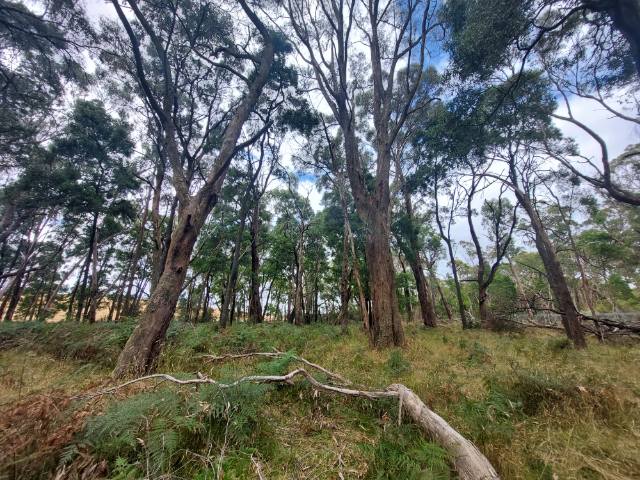
The second reference community that is exists on the property, is dominated by swamp gum (Eucalyptus ovata) and rough-barked manna gum (Eucalyptus viminalis ssp. cygnetensis). This vegetation type is common throughout the surrounding landscape, and around the boundary. On the Mt Vandyke property this community was probably found only on the flatter country fringing the hill, which has deeper soils.
To help us refine our understanding of how these communities were originally distributed at Mt Vandyke we have been lucky to have La Trobe University student, Charlotte Hall, undertaking her final year placement with us in January 2023. Charlotte has been undertaking detailed surveys at the site, including establishing vegetation quadrats in our reference communities and grassland trial site, and developing a soil map (identifying soil type, depth, and permeability). Charlotte’s work will considerably add to our understanding of the site and will be combined with other data to help us finalise our restoration approach.
Stay tuned, as in the coming months we’ll be sharing more about our restoration plan and kicking off on-ground restoration with the direct seeding of 1.5 hectares of grassland trial site.
You can read more about the evolution of our Mt Vandyke project in these previous articles, describing the site and our early thoughts about habitat restoration,
We gratefully acknowledge our generous supporters and donors in making the purchase and on-going restoration of the site a reality.


