Missing mudflats – Can we restore vital habitat for shorebirds in Lake Hawdon North?
Readers will be aware from past blogs that NGT, in collaboration with the South Australian (SA) and Commonwealth Governments, has been investigating the restoration potential of Lake Hawdon North for several years. This 2,500 hectare seasonal wetland fills most years, but drains rapidly due to the influence of Drain L, one of the largest and highest yielding artificial drains in the South East of SA. This drain was excavated directly through the bed of the wetland, first in 1915 and then enlarged in 1958. One of the first investigations we undertook, back in 2020, was a comprehensive Restoration Feasibility Assessment of the wetland. With this report now approved for public release we thought it timely to revisit the questions of what the restoration of Lake Hawdon North (LHN) would involve and what could be achieved.
Taylor-2020-restoration-feasibility-assessment-Lake-Hawdon-North
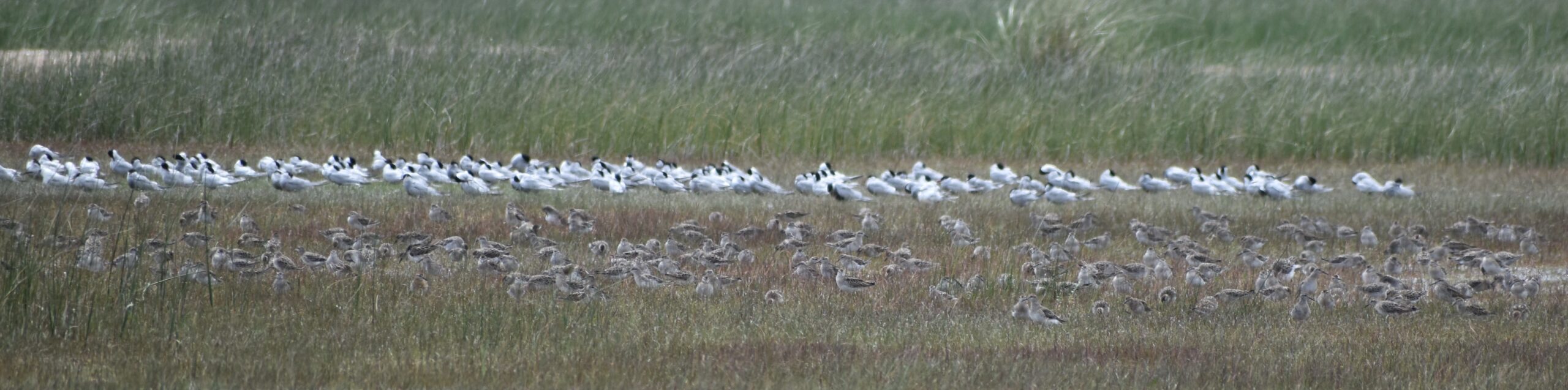
Of particular interest is the potential of the restoration of LHN to increase habitat availability for five species of shorebird. These five species have declined in abundance in the Coorong South Lagoon due it’s degraded state, a consequence of the over-allocation of water within the Murray-Daring Basin and the drainage of the South East of SA. The species are the migratory sharp-tailed sandpiper (Calidris acuminata), curlew sandpiper (Calidris ferruginea), red-necked stint (Calidris ruficollis) and common greenshank (Tringa nebularia) and the non-migratory red-capped plover (Charadrius ruficapillus). They are all found in LHN, but only when water is present.
These shorebird species all feed in shallow, open mudflats less than 10-cm deep. This type of habitat is present in LHN, typically from early June until mid-December, after which the wetland is mostly dry. Migratory shorebirds are present in southern Australia, and in need of feeding habitat, from mid-October through to mid-March, after which they migrate back to breeding grounds in the arctic. You may be able to recognise the discrepancy here. Under current management, LHN is so effectively drained by Drain L that it provides no habitat for migratory shorebirds after around mid-December, leaving a gap of about 3 months! Yet prior to drainage, multiple lines of evidence tell us that LHN would have retained shallow water and provided shorebird habitat through to the end of summer in most years.
Hydrological restoration would involve constructing a regulator across Drain L at the location it exits LHN (see image below). The regulator would need to be adjustable and be completely open without impeding flows during high Drain L flows, to protect upstream agricultural land from unwanted inundation, but able to be partially or completely closed to maintain a particular water level in LHN under lower flows, when the season turns. It would also need to incorporate a fish ladder given there are species using the site, which we wish to maintain, that now migrate into Lake Hawdon from the sea via Drain L.

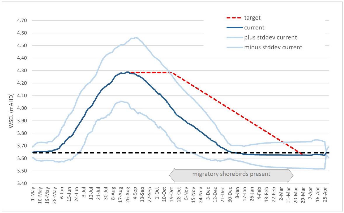
The lowest lying areas of the bed of LHN have an elevation of 3.65 mAHD. When the water surface elevation reaches 4.30 mAHD (i.e. 65 cm deep in the deepest areas) LHN is effectively full under its modern management regime and the expectations of neighbours. Water levels do get higher, over 4.80 mAHD at times, but these are conditions under which adjoining private, agricultural land temporarily becomes inundated. The objective of the regulator would be to extend the receding ‘arm’ of the hydrograph for the wetland, i.e. keeping it full for as long as possible, then allowing it to decline more gradually than it does now. This is predicted to maintain some water in LHN until mid-March (see graph below). Revised modelling completed recently confirms that an outcome which almost matches the target hydrograph can be achieved in an average rainfall year.
Aerial imagery from the 1950s tells us that the formerly open mudflat habitat required for shorebirds has reduced at Lake Hawdon North, as it has been colonised by salt paperbark (Melaleuca halmaturorum) shrubland. This woody native species has invaded the lake bed in response to the drying of the wetland caused by Drain L, a human-induced trend of habitat degradation that we see repeated in many dehydrated wetlands and floodplains across the whole region (what we refer to as ‘terrestrialisation’). Salt paperbark forms dense monocultures that we know are low in bird diversity and abundance. To restore more of the open, mudflat habitat favoured by shorebirds, the restoration proposal also includes the remediation of 650 hectares of the lake bed where this novel shrubland monoculture has invaded the wetland. This intervention is required because the size of these now well-established and very hardy shrubs, means that hydrological restoration alone will not drown them, hence physical removed is necessary. However, the restored water regime will greatly help retain the open mudflat habitat and prevent reinvasion by shrubs, by increasing the duration of annual inundation. Of note, sheep grazing will also play an important role in retaining this mudflat habitat with an appropriate structure, because hydrological restoration alone is not be sufficient to mimic the original (pre-European) depth of Lake Hawdon (as this would impact large areas of adjacent, now drained agricultural land). LHN is currently grazed under license and there is strong evidence that grazing helps limit shrub invasion. This management tool is anticipated to be even more effective in combination with the proposed hydrological restoration works.
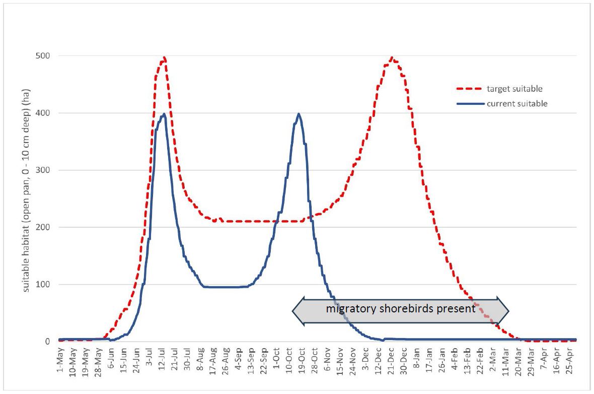
As part of the Restoration Feasibility Assessment, we endeavoured to quantify the improvement that restoration would make to habitat availability for the target shorebird species. The graph below shows the area of target shorebird habitat (open mudflats up to 10 cm deep) in LHN as the water surface elevation (WSEL) increases from dry (3.65 mAHD) through to full (4.30 mAHD). Interestingly, because of this direct relationship to water depth, the maximum amount of shorebird habitat in LHN occurs when the wetland is about half full, with a WSEL of 4.02 mAHD. As the water level increases above this, much of LHN becomes too deep for shorebirds and suitable habitat becomes confined to the outer margins. As shown by the blue line in the graph below, the remediation of mudflats that have been invaded by salt paperbark shrubland increases the amount of target shorebird habitat across all water levels.

However, the above graph does not tell the whole story, because proposed restoration involves both salt paperbark clearance AND extending the period of inundation. The graph below shows the combined effects of both. Importantly, using a regulator to hold water for longer in LHN better aligns the period of shorebird habitat availability with the period that migratory shorebirds are present in southern Australia. In fact, the maximum amount of shorebird habitat (500 ha) would occur in late December, pretty much the mid-point of the shorebird season. This would amount to a massive increase in the capacity of LHN to support shorebirds, about a 530% increase compared to the current situation!
There are a number of other issues to consider for the restoration of Lake Hawdon North. One of the most important is ensuring that sufficient water continues to flow downstream to maintain the ecological values of the Robe Lakes. This issue was explored in detail in another report recently approved for public release – so, stay tuned for a future blog.
The proposed restoration of Lake Hawdon North is currently being considered by the SA Government Department for Environment and Water and the Commonwealth Department of Climate Change, Energy, the Environment and Water as part of the On-Ground Works Project of the Healthy Coorong, Healthy Basin Program.