National spotlight on the Great South West Walk – the beautiful hike that takes you past three NGT project sites!
Thanks to a recent episode of ABC TV’s Back Roads, I’ve had a few people reach out in the past couple of weeks to ask me about my own ‘backyard’ in the cross-border zone between Victoria and South Australia – a special part of the landscape that incorporates the Great South West Walk.
The ABC researchers who were working on developing the content for this episode contacted me late last year, as they were narrowing down their list of potential stories to incorporate. We discussed a few NGT projects taking place in the landscape along the walk, but unfortunately we didn’t make the cut. They clearly had lots of worthwhile stories to choose from – including some very personal and moving ones – and half an hour is never enough to explore everything a landscape has to offer. But fear not, luckily we have the NGT blogs ready to help fill in the gaps!
My own experience of properly tackling the complete Great South West Walk circuit happened in three stages from 2010 to 2014. Looking back in retrospect, it also turns out that each stage took me along a section of the walk that now has a very strong connection to NGT – as you will see below:
The first leg in 2010: Home to Portland (and the site of the Long Swamp Restoration project)
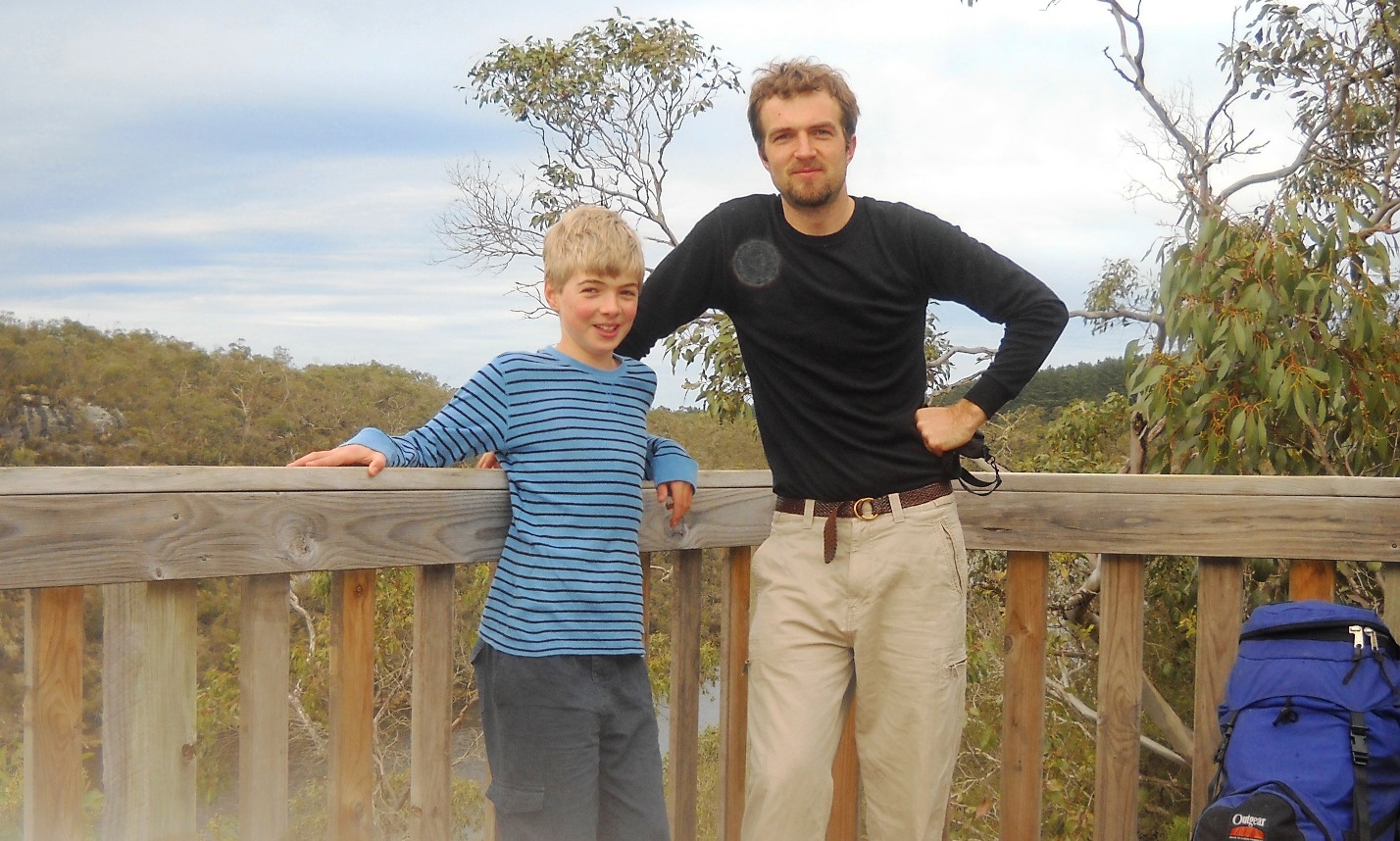
The first leg of the walk was something I tackled back in 2010 with my eldest son Brendan, when he turned 13, and we kicked it off from our unofficial starting point at our home near Rennick, which is about 25km north of the actual walk, on the ‘wrong’ (i.e. north) side of the river. Our unofficial route took us through Rennick State forest and pine plantations down to Nelson, via Donovans, on the outside of river, before we reached Nelson and then jumped onto the official path.
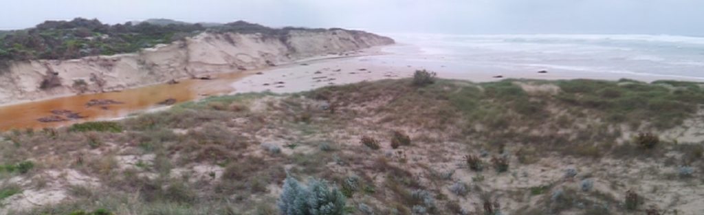
As we pushed on along the beach from Nelson towards Cape Bridgewater, we camped at the old White Sands campground – which has now been decommissioned and was once the most remote camp on the walk, making it difficult for the Friends of the Walk volunteers to maintain. It also turned out that the old campground was partly underwater at the time, because the artificial outlet to the sea at White Sands (the first of two artificial outlets to the sea from Long Swamp) had naturally closed a few years prior, during the Millennium Drought. I didn’t realise the significance of this at the time, but fortunately I took a few photos – including the roughly stitched image below. This view shows (1) the newly impounded wetland behind the dunes, (2) the reformed foredune (left) that had naturally blocked the artificial outlet and (3) part of the old campground and toilet in the foreground.

The restored wetland at White Sands ended up providing a useful reference point for what would become one of NGT’s first and longest-running community based wetland restoration projects at Nobles Rocks, a little further east along the Discovery Bay coast. In 2010, back before NGT was even an idea yet, and in contrast to conditions at White Sands, the artificial outlet from Long Swamp at Nobles Rocks was running freely into the ocean, as it had done ever since it was opened up in the 1930s, causing erosion of the beach and dunes.


Fast forward to today and as a result of a restoration trial that began in 2014/15, this entire areas has been transformed. The final phase of the trial was an absolutely huge combined effort led by NGT with incredible community support (including Gordon Page and others from the Friends of the Walk). The task involved filling, shifting and placing 7000 geo-fabric sandbags to restore water levels within Long Swamp and reinstate natural flows back towards the Glenelg River estuary and mouth.
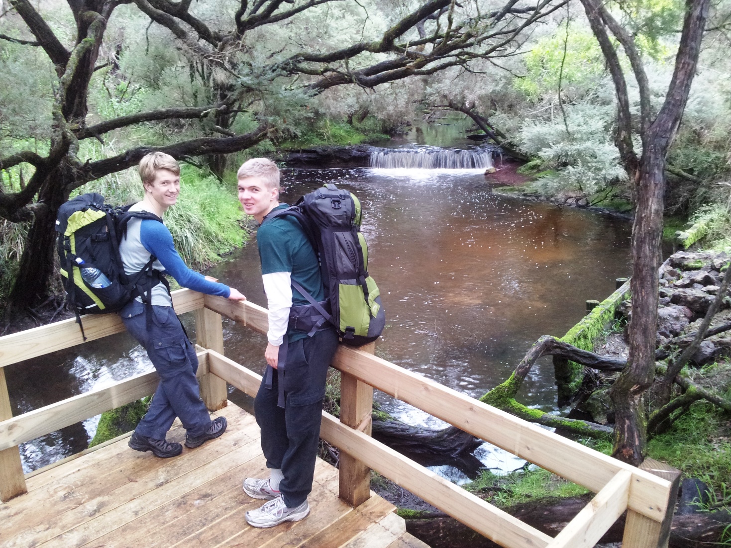
I was personally rapt to have my two other sons (Caleb and Dale) involved every step of the way with this process as it unfolded over 12 days in autumn 2015, volunteering to help as part of their home education journey. While writing this, it has reminded me of a funny moment of celebration when former NGT staff member Adam Miller and Dale came good on their agreement to take a dip in the restored wetland behind the new trial structure upon completion – in the photo shown here they are smiling, but I can still remember their comments (or was it shrieks!?) about how cold the water was!
The later permanent restoration works of 2019 involved pumping around 500 cubic metres of sand over the 7000-sandbag structure near Nobles Rocks, to restore the natural dune and permanently close the former artificial channel. Revegetation of the dune slopes followed in 2019 and 2020, but all the time, the action of wind and water in this dynamic and high energy coastal environment have been reshaping the former channel and previously eroded coastline.
Sand has gradually been filling in the formerly free-flowing drain (for a previous update click here), and on the beach where it used to flow to the sea a huge volume of sand is building up, continuing to knit together a new foredune.
Jumping back now to the 2010 hike, and beyond Nobles Rocks, we continued all the way to Portland, where we experienced the rest of the sandy Discovery Bay coast, and then the headlands and cliffs around Cape Bridgewater.
The second leg in 2012: Portland to Heath Road, Lower Glenelg National Park (and the origins of the Mt Vandyke Restoration project)
Fast forward a couple of years, and a few months after NGT was launched in January 2012, I returned with Brendan to tackle our second leg of the journey, and this time we were joined by Thai Te, an old friend from our university days in Adelaide. You can read a little about that journey in the NGT blogs here.

Something that I didn’t have any reason to mention in the blogs back in 2012, was that this was also when I first came across Mt Vandyke (now an NGT Reserve) – because the walking track actually runs along the southern boundary of this unique private property, which is centred over an extinct volcanic peak. The rare potential to do something special at Mt Vandyke, being completely surrounded by National Park, felt immediately obvious to me at the time, and – as is the way for me with environmental project ideas – it got my brain ticking over while we continued the hike… indeed, with the benefit of hindsight, this is the formative moment that our present-day restoration project at this site can now be traced back to.
It turned out that with the blue gums on the property recently harvested, the property was actually placed on the market in 2012, however – because NGT had only literally just begun operating – we were unable to get the necessary finance organised in time.

To say that I was disappointed at NGT missing out is a bit of an understatement (absolutely gutted would be a more accurate description!), but not to be deterred, the idea for one day kicking off a project at the site kept bubbling away. Hence when my son Caleb told me that he had seen the property back on the market in late 2019, NGT was in a much better financial position to act and didn’t hesitate, taking out a loan to secure the property and settling the purchase in mid-2020.
We eventually made the project public in autumn 2021, and were amazed by the public response, ultimately paying off the loan by the end of that calendar year. And just like that, this exciting long-term project which is working to restore threatened grasslands and reintroduce threatened mammals, inside a new feral-predator free safe haven, was off and running!
Continuing with the hike in 2012, and we pressed on until we reached Lower Glenelg National Park, completing the absolutely beautiful Cobboboonee forest section of the walk, and ready for the final stretch along the river to come…
The third and final leg in 2014: Heath Road to Nelson along the Lower Glenelg River (and past Kurrawonga)
It was another two years later, in June 2014, that myself and Brendan returned for the final leg, this time joined by my second son Caleb.
We picked up the hike again from Heath Road, and trekked across the Kentbruck Heath and then along the top of the spectacular limestone cliffs of the Lower Glenelg River, following it down to Nelson. Little did I know at the time, but this section of the hike would take us skirting close to the south-western corner of Kurrawonga, a beautiful bush property that would later become an NGT Reserve in 2018. You can read about the story of Kurrawonga, and the wonderful generosity of the Moore family here.
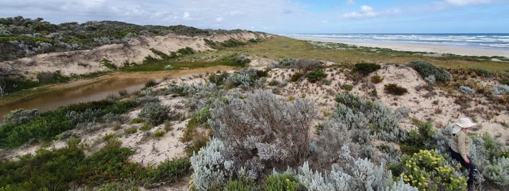
In fact, it was fantastic to spend a bit of time again just a few weeks ago with John and Andrew Moore (two of Bill and Kate Moore’s five children), as they returned to visit Kurrawonga and take a look around a number of NGT’s projects with me across the region. In keeping with the theme of this story and in-fact bringing it full circle, it turned out that the first place we visited was the Long Swamp restoration project site at Nobles Rocks! Here we witnessed the wetland and dune environment recovery process as it continues to unfold, as shown below.
To sum up, as you can tell the Great South West Walk is not only intertwined with the story of a few important NGT projects, but it also connects many of us in a very personal way with this special landscape. To learn more about the ABC Back Roads story and discover some of those other wonderful personal stories of connection – and for a link to the episode on ABC’s i-view – please click this link.
